

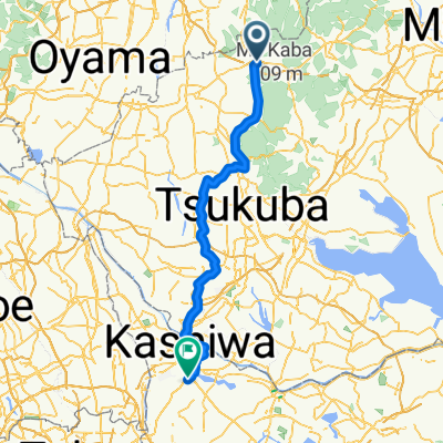
山桜と石の街散策コース
A cycling route starting in Iwase, Ibaraki, Japan.
Overview
About this route
- -:--
- Duration
- 22.3 km
- Distance
- 111 m
- Ascent
- 113 m
- Descent
- ---
- Avg. speed
- ---
- Max. altitude

Route quality
Waytypes & surfaces along the route
Waytypes
Road
8.3 km
(37 %)
Quiet road
5.6 km
(25 %)
Surfaces
Paved
5.1 km
(23 %)
Paved (undefined)
3.3 km
(15 %)
Asphalt
1.8 km
(8 %)
Undefined
17.2 km
(77 %)
Continue with Bikemap
Use, edit, or download this cycling route
You would like to ride 山桜と石の街散策コース or customize it for your own trip? Here is what you can do with this Bikemap route:
Free features
- Save this route as favorite or in collections
- Copy & plan your own version of this route
- Sync your route with Garmin or Wahoo
Premium features
Free trial for 3 days, or one-time payment. More about Bikemap Premium.
- Navigate this route on iOS & Android
- Export a GPX / KML file of this route
- Create your custom printout (try it for free)
- Download this route for offline navigation
Discover more Premium features.
Get Bikemap PremiumFrom our community
Other popular routes starting in Iwase
 つくば霞ヶ浦りんりんロード, 桜川市へ犬田, 桜川市
- Distance
- 0.8 km
- Ascent
- 3 m
- Descent
- 3 m
- Location
- Iwase, Ibaraki, Japan
 あから柏駅
あから柏駅- Distance
- 77.8 km
- Ascent
- 218 m
- Descent
- 234 m
- Location
- Iwase, Ibaraki, Japan
 一本杉峠・風返峠
- Distance
- 55.1 km
- Ascent
- 979 m
- Descent
- 1,005 m
- Location
- Iwase, Ibaraki, Japan
 一般県道岩瀬土浦自転車道線(筑波自転車道)
- Distance
- 40 km
- Ascent
- 78 m
- Descent
- 122 m
- Location
- Iwase, Ibaraki, Japan
 Slow ride in Tsuchiura-Shi
- Distance
- 41 km
- Ascent
- 45 m
- Descent
- 98 m
- Location
- Iwase, Ibaraki, Japan
 山桜と石の街散策コース
- Distance
- 22.3 km
- Ascent
- 111 m
- Descent
- 113 m
- Location
- Iwase, Ibaraki, Japan
 松屋製麺所⇒岩瀬駅
- Distance
- 4.6 km
- Ascent
- 29 m
- Descent
- 18 m
- Location
- Iwase, Ibaraki, Japan
 つくばリンリンロード
- Distance
- 40.4 km
- Ascent
- 36 m
- Descent
- 70 m
- Location
- Iwase, Ibaraki, Japan
Open it in the app