

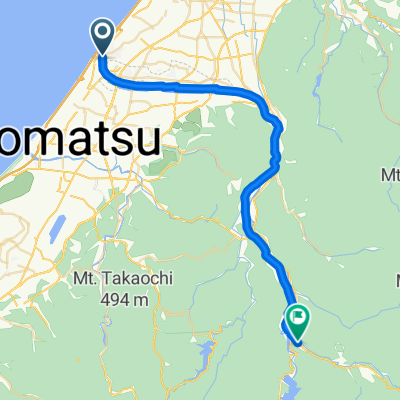
白山手取川ルート
A cycling route starting in Matsutō, Ishikawa, Japan.
Overview
About this route
- -:--
- Duration
- 106.8 km
- Distance
- 1,549 m
- Ascent
- 1,549 m
- Descent
- ---
- Avg. speed
- ---
- Max. altitude

Route quality
Waytypes & surfaces along the route
Waytypes
Cycleway
41.7 km
(39 %)
Path
24.6 km
(23 %)
Surfaces
Paved
60.9 km
(57 %)
Asphalt
32 km
(30 %)
Paved (undefined)
28.8 km
(27 %)
Undefined
45.9 km
(43 %)
Continue with Bikemap
Use, edit, or download this cycling route
You would like to ride 白山手取川ルート or customize it for your own trip? Here is what you can do with this Bikemap route:
Free features
- Save this route as favorite or in collections
- Copy & plan your own version of this route
- Split it into stages to create a multi-day tour
- Sync your route with Garmin or Wahoo
Premium features
Free trial for 3 days, or one-time payment. More about Bikemap Premium.
- Navigate this route on iOS & Android
- Export a GPX / KML file of this route
- Create your custom printout (try it for free)
- Download this route for offline navigation
Discover more Premium features.
Get Bikemap PremiumFrom our community
Other popular routes starting in Matsutō
 県道25号, Hakusan-Shi to 65-2, Mikawanakamachi Ni, Hakusan-Shi
- Distance
- 17.7 km
- Ascent
- 0 m
- Descent
- 7 m
- Location
- Matsutō, Ishikawa, Japan
 2345−1, 白山市 to ハ,かなぬねやなぬヨヌやソニヤぬ梁やヨユな湯ユヌや粗野なの野や(ノノやな名やユヌ2のユワにやりな湯)骨ゅな梁や床布ユニ湯(カナ米まな中津幡ですななや)ゆねな(ぬぬのやゆやぬのやゆにの(なやぬのやらやのろさそさそはわろ…ろんわ… 津幡町
- Distance
- 21.6 km
- Ascent
- 56 m
- Descent
- 61 m
- Location
- Matsutō, Ishikawa, Japan

 甲 までヴィラ メルヴェイユ
- Distance
- 62.3 km
- Ascent
- 319 m
- Descent
- 355 m
- Location
- Matsutō, Ishikawa, Japan

 1丁目 8, 白山市 to 志賀町
- Distance
- 86.7 km
- Ascent
- 755 m
- Descent
- 752 m
- Location
- Matsutō, Ishikawa, Japan
 Miyamarumachi, Hakusan-Shi to 県道54号, Komatsu-Shi
- Distance
- 16.7 km
- Ascent
- 19 m
- Descent
- 33 m
- Location
- Matsutō, Ishikawa, Japan
 ハ, 白山市 to 寅, 白山市
- Distance
- 36 km
- Ascent
- 514 m
- Descent
- 204 m
- Location
- Matsutō, Ishikawa, Japan
Open it in the app