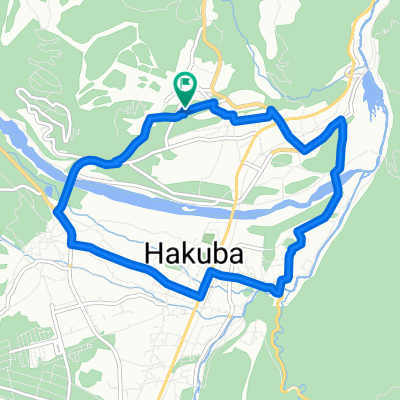
歴史が薫る田園風景ルート
A cycling route starting in Hakuba, Nagano, Japan.
Overview
About this route
- -:--
- Duration
- 43.4 km
- Distance
- 931 m
- Ascent
- 1,095 m
- Descent
- ---
- Avg. speed
- ---
- Max. altitude
Route quality
Waytypes & surfaces along the route
Waytypes
Road
10.9 km
(25 %)
Quiet road
8.7 km
(20 %)
Surfaces
Paved
1.7 km
(4 %)
Unpaved
0.4 km
(1 %)
Paved (undefined)
1.3 km
(3 %)
Asphalt
0.4 km
(1 %)
Continue with Bikemap
Use, edit, or download this cycling route
You would like to ride 歴史が薫る田園風景ルート or customize it for your own trip? Here is what you can do with this Bikemap route:
Free features
- Save this route as favorite or in collections
- Copy & plan your own version of this route
- Sync your route with Garmin or Wahoo
Premium features
Free trial for 3 days, or one-time payment. More about Bikemap Premium.
- Navigate this route on iOS & Android
- Export a GPX / KML file of this route
- Create your custom printout (try it for free)
- Download this route for offline navigation
Discover more Premium features.
Get Bikemap PremiumFrom our community
Other popular routes starting in Hakuba
Rural Scene Along the Hime River- Distance
- 12.1 km
- Ascent
- 122 m
- Descent
- 123 m
- Location
- Hakuba, Nagano, Japan
CHARIP Rhythm_HAKUBA 250708- Distance
- 35.5 km
- Ascent
- 421 m
- Descent
- 420 m
- Location
- Hakuba, Nagano, Japan
八方コース- Distance
- 10.4 km
- Ascent
- 180 m
- Descent
- 182 m
- Location
- Hakuba, Nagano, Japan
Scenic Short Spots Route- Distance
- 8.8 km
- Ascent
- 109 m
- Descent
- 107 m
- Location
- Hakuba, Nagano, Japan
さのさかコース- Distance
- 10.2 km
- Ascent
- 108 m
- Descent
- 108 m
- Location
- Hakuba, Nagano, Japan
岩岳コース- Distance
- 10.1 km
- Ascent
- 165 m
- Descent
- 167 m
- Location
- Hakuba, Nagano, Japan
ヒルクライム 白沢峠コース- Distance
- 7.7 km
- Ascent
- 454 m
- Descent
- 44 m
- Location
- Hakuba, Nagano, Japan
Nishina three lakes and Mt.Koguma Hill Climb- Distance
- 57.1 km
- Ascent
- 1,294 m
- Descent
- 1,299 m
- Location
- Hakuba, Nagano, Japan
Open it in the app


