
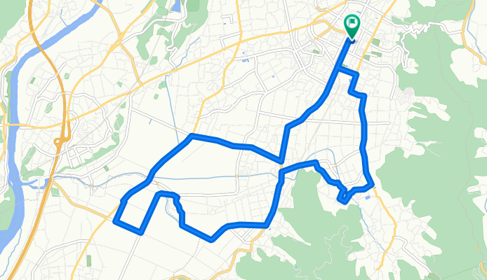
中山晋平記念館と北信五岳パノラマルート
A cycling route starting in Nakano, Nagano, Japan.
Overview
About this route
- -:--
- Duration
- 15.8 km
- Distance
- 107 m
- Ascent
- 107 m
- Descent
- ---
- Avg. speed
- ---
- Max. altitude

Route quality
Waytypes & surfaces along the route
Waytypes
Quiet road
5.8 km
(37 %)
Road
4.1 km
(26 %)
Surfaces
Paved
2.7 km
(17 %)
Paved (undefined)
2.7 km
(17 %)
Undefined
13.1 km
(83 %)
Continue with Bikemap
Use, edit, or download this cycling route
You would like to ride 中山晋平記念館と北信五岳パノラマルート or customize it for your own trip? Here is what you can do with this Bikemap route:
Free features
- Save this route as favorite or in collections
- Copy & plan your own version of this route
- Sync your route with Garmin or Wahoo
Premium features
Free trial for 3 days, or one-time payment. More about Bikemap Premium.
- Navigate this route on iOS & Android
- Export a GPX / KML file of this route
- Create your custom printout (try it for free)
- Download this route for offline navigation
Discover more Premium features.
Get Bikemap PremiumFrom our community
Other popular routes starting in Nakano
 中山晋平記念館と北信五岳パノラマルート
- Distance
- 15.8 km
- Ascent
- 107 m
- Descent
- 107 m
- Location
- Nakano, Nagano, Japan
 草津~沼田(2016Tour-Kusatsu-Numata)
- Distance
- 83.8 km
- Ascent
- 787 m
- Descent
- 1,386 m
- Location
- Nakano, Nagano, Japan
 Nancy Gray Day 3 Shibu-onsen - Nozawa Onsen
- Distance
- 36.5 km
- Ascent
- 738 m
- Descent
- 860 m
- Location
- Nakano, Nagano, Japan
 yudanaka shijiri
- Distance
- 119.2 km
- Ascent
- 1,021 m
- Descent
- 884 m
- Location
- Nakano, Nagano, Japan
 湯田中・渋温泉郷・地獄谷野猿公苑ルート
- Distance
- 11.2 km
- Ascent
- 395 m
- Descent
- 396 m
- Location
- Nakano, Nagano, Japan
 09-25-2013_Day22
- Distance
- 88.5 km
- Ascent
- 2,321 m
- Descent
- 1,823 m
- Location
- Nakano, Nagano, Japan
 飯綱・一面のりんご畑を走るルート
- Distance
- 11.1 km
- Ascent
- 209 m
- Descent
- 207 m
- Location
- Nakano, Nagano, Japan
 20110811 木戸池 - 野反湖
- Distance
- 55.3 km
- Ascent
- 1,417 m
- Descent
- 1,493 m
- Location
- Nakano, Nagano, Japan
Open it in the app