

برنامه رکاب زنی در تاریخ ۱۳۹۸/۱۲/۱۶
A cycling route starting in Behbahān, Khuzestan, Iran.
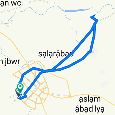
Overview
About this route
- 6 h 41 min
- Duration
- 75 km
- Distance
- 368 m
- Ascent
- 353 m
- Descent
- 11.2 km/h
- Avg. speed
- ---
- Max. altitude

Route photos


Continue with Bikemap
Use, edit, or download this cycling route
You would like to ride برنامه رکاب زنی در تاریخ ۱۳۹۸/۱۲/۱۶ or customize it for your own trip? Here is what you can do with this Bikemap route:
Free features
- Save this route as favorite or in collections
- Copy & plan your own version of this route
- Sync your route with Garmin or Wahoo
Premium features
Free trial for 3 days, or one-time payment. More about Bikemap Premium.
- Navigate this route on iOS & Android
- Export a GPX / KML file of this route
- Create your custom printout (try it for free)
- Download this route for offline navigation
Discover more Premium features.
Get Bikemap PremiumFrom our community
Other popular routes starting in Behbahān
 Relaxed route
- Distance
- 19.6 km
- Ascent
- 75 m
- Descent
- 52 m
- Location
- Behbahān, Khuzestan, Iran
 Supersonic route
- Distance
- 22.3 km
- Ascent
- 86 m
- Descent
- 78 m
- Location
- Behbahān, Khuzestan, Iran
 Moderate route
- Distance
- 10.8 km
- Ascent
- 20 m
- Descent
- 23 m
- Location
- Behbahān, Khuzestan, Iran
 بهبهان نرگسزار پنجشنبه ۲۳ دی ۱۴۰۰
- Distance
- 30 km
- Ascent
- 197 m
- Descent
- 197 m
- Location
- Behbahān, Khuzestan, Iran
 , Behbahan to , Behbahan
- Distance
- 26.7 km
- Ascent
- 312 m
- Descent
- 315 m
- Location
- Behbahān, Khuzestan, Iran
 ۱۳۹۸/۱۲/۱۵ مسیر تنگ تهلیو
- Distance
- 21.8 km
- Ascent
- 126 m
- Descent
- 118 m
- Location
- Behbahān, Khuzestan, Iran
 Moderate route
- Distance
- 29.2 km
- Ascent
- 97 m
- Descent
- 81 m
- Location
- Behbahān, Khuzestan, Iran
 Steady ride
- Distance
- 14.4 km
- Ascent
- 30 m
- Descent
- 32 m
- Location
- Behbahān, Khuzestan, Iran
Open it in the app