

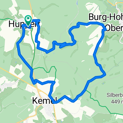
Burg Hohenstein - SWA - Kemel
A cycling route starting in Reckenroth, Rhineland-Palatinate, Germany.
Overview
About this route
Huppert - durch den Wlad Richtun Burg Hohenstein - Radweg folgen Richtung Adolfseck - durch Adolfseck durch und kurz nach dem Ortsschild rechts auf den Radweg - Richtung SWA - etwas Straße in Bad Schalbach in Richtung Kreisverwaltung - über dem Schwimmbad vorbei - dem Radweg bis nach Heimbach folgen - in Heimbach unter dem lila Haus auf den Weg - an den Windrädern von Kemel vorbei - durch Kemel und am 'Industriegebiet' vorbei - an Mappershain vorbei - am Erlenhof vorbei - Grillplatz Huppert - FERTIG! :)
- -:--
- Duration
- 27.1 km
- Distance
- 479 m
- Ascent
- 479 m
- Descent
- ---
- Avg. speed
- ---
- Max. altitude

Continue with Bikemap
Use, edit, or download this cycling route
You would like to ride Burg Hohenstein - SWA - Kemel or customize it for your own trip? Here is what you can do with this Bikemap route:
Free features
- Save this route as favorite or in collections
- Copy & plan your own version of this route
- Sync your route with Garmin or Wahoo
Premium features
Free trial for 3 days, or one-time payment. More about Bikemap Premium.
- Navigate this route on iOS & Android
- Export a GPX / KML file of this route
- Create your custom printout (try it for free)
- Download this route for offline navigation
Discover more Premium features.
Get Bikemap PremiumFrom our community
Other popular routes starting in Reckenroth
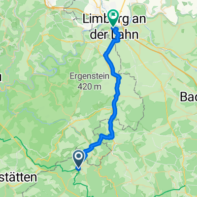
 Langschied - Egenroth
- Distance
- 2.4 km
- Ascent
- 40 m
- Descent
- 80 m
- Location
- Reckenroth, Rhineland-Palatinate, Germany
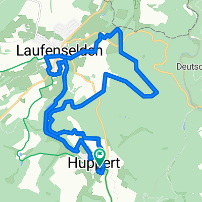 Huppert - Laufenselden
- Distance
- 14.6 km
- Ascent
- 257 m
- Descent
- 257 m
- Location
- Reckenroth, Rhineland-Palatinate, Germany
 Feierabendrunde in Heidenrod
- Distance
- 16.6 km
- Ascent
- 274 m
- Descent
- 274 m
- Location
- Reckenroth, Rhineland-Palatinate, Germany
 Happy Friday Routine
- Distance
- 15.8 km
- Ascent
- 286 m
- Descent
- 286 m
- Location
- Reckenroth, Rhineland-Palatinate, Germany
 Burg Hohenstein - SWA - Kemel
- Distance
- 27.1 km
- Ascent
- 479 m
- Descent
- 479 m
- Location
- Reckenroth, Rhineland-Palatinate, Germany
 Dammstraße nach Schiede
- Distance
- 28.4 km
- Ascent
- 217 m
- Descent
- 467 m
- Location
- Reckenroth, Rhineland-Palatinate, Germany
 Huppert - Burg Hohenstein - Kemel
- Distance
- 15 km
- Ascent
- 278 m
- Descent
- 278 m
- Location
- Reckenroth, Rhineland-Palatinate, Germany
 Sonntags-„Spaziergang“ zum 1. Advent
- Distance
- 15.1 km
- Ascent
- 655 m
- Descent
- 658 m
- Location
- Reckenroth, Rhineland-Palatinate, Germany
Open it in the app