

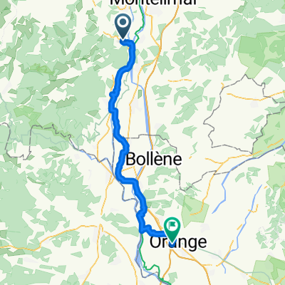
16: ViaRhôna de Viviers / Bourg-Saint-Andéol à Lapalud
A cycling route starting in Viviers, Auvergne-Rhône-Alpes, France.
Overview
About this route
Leaving Châteauneuf-du-Rhône, following the lônes, you will reach Viviers with its medieval soul, Bourg-Saint-Andéol and its mythical bas-relief of the god Mithras. This ViaRhôna stage with a strong heritage emphasis features numerous chapels, cathedrals, and palaces of these historic towns... Lovers of nature and history will be captivated! The route goes along greenways and small roads. Marked from the exit of Viviers.
- -:--
- Duration
- 31.8 km
- Distance
- 107 m
- Ascent
- 117 m
- Descent
- ---
- Avg. speed
- ---
- Max. altitude

Route quality
Waytypes & surfaces along the route
Waytypes
Quiet road
15.3 km
(48 %)
Cycleway
6.7 km
(21 %)
Surfaces
Paved
26.4 km
(83 %)
Unpaved
1.9 km
(6 %)
Asphalt
26.1 km
(82 %)
Unpaved (undefined)
1 km
(3 %)
Continue with Bikemap
Use, edit, or download this cycling route
You would like to ride 16: ViaRhôna de Viviers / Bourg-Saint-Andéol à Lapalud or customize it for your own trip? Here is what you can do with this Bikemap route:
Free features
- Save this route as favorite or in collections
- Copy & plan your own version of this route
- Sync your route with Garmin or Wahoo
Premium features
Free trial for 3 days, or one-time payment. More about Bikemap Premium.
- Navigate this route on iOS & Android
- Export a GPX / KML file of this route
- Create your custom printout (try it for free)
- Download this route for offline navigation
Discover more Premium features.
Get Bikemap PremiumFrom our community
Other popular routes starting in Viviers
 Rhone 1/5
- Distance
- 66.7 km
- Ascent
- 73 m
- Descent
- 111 m
- Location
- Viviers, Auvergne-Rhône-Alpes, France
 2014_E12_Viviers_Sanilhac
- Distance
- 81.5 km
- Ascent
- 439 m
- Descent
- 364 m
- Location
- Viviers, Auvergne-Rhône-Alpes, France
 Dia 4 - Viviers a Avignon
- Distance
- 82.7 km
- Ascent
- 283 m
- Descent
- 326 m
- Location
- Viviers, Auvergne-Rhône-Alpes, France
 Bourg-Saint-Andéol - Avignon
- Distance
- 82.9 km
- Ascent
- 177 m
- Descent
- 220 m
- Location
- Viviers, Auvergne-Rhône-Alpes, France
 rocheconderie to orange
- Distance
- 58.8 km
- Ascent
- 163 m
- Descent
- 197 m
- Location
- Viviers, Auvergne-Rhône-Alpes, France
 16: ViaRhôna de Viviers / Bourg-Saint-Andéol à Lapalud
- Distance
- 31.8 km
- Ascent
- 107 m
- Descent
- 117 m
- Location
- Viviers, Auvergne-Rhône-Alpes, France
 Donère->Frontignan
- Distance
- 202 km
- Ascent
- 434 m
- Descent
- 511 m
- Location
- Viviers, Auvergne-Rhône-Alpes, France
 Place de la Roubine 2, Viviers nach L'Argentane 17, Saint-Paul-Trois-Châteaux
- Distance
- 21.1 km
- Ascent
- 178 m
- Descent
- 155 m
- Location
- Viviers, Auvergne-Rhône-Alpes, France
Open it in the app