

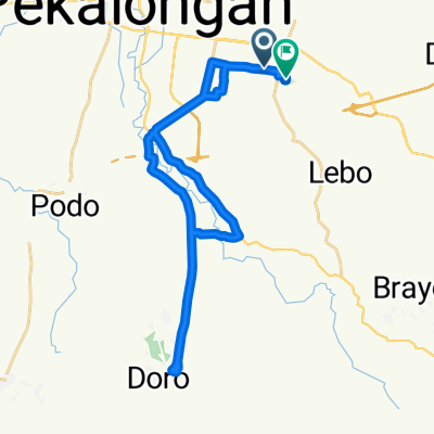
High-speed route in Kecamatan Batang
A cycling route starting in Batang, Central Java, Indonesia.
Overview
About this route
- 1 h 57 min
- Duration
- 32.8 km
- Distance
- 267 m
- Ascent
- 252 m
- Descent
- 16.8 km/h
- Avg. speed
- ---
- Max. altitude

Route quality
Waytypes & surfaces along the route
Waytypes
Quiet road
6.2 km
(19 %)
Road
1.6 km
(5 %)
Undefined
24.9 km
(76 %)
Continue with Bikemap
Use, edit, or download this cycling route
You would like to ride High-speed route in Kecamatan Batang or customize it for your own trip? Here is what you can do with this Bikemap route:
Free features
- Save this route as favorite or in collections
- Copy & plan your own version of this route
- Sync your route with Garmin or Wahoo
Premium features
Free trial for 3 days, or one-time payment. More about Bikemap Premium.
- Navigate this route on iOS & Android
- Export a GPX / KML file of this route
- Create your custom printout (try it for free)
- Download this route for offline navigation
Discover more Premium features.
Get Bikemap PremiumFrom our community
Other popular routes starting in Batang
 271019
- Distance
- 37.6 km
- Ascent
- 375 m
- Descent
- 387 m
- Location
- Batang, Central Java, Indonesia
 bike baik saja...131019
- Distance
- 39.3 km
- Ascent
- 649 m
- Descent
- 646 m
- Location
- Batang, Central Java, Indonesia
 100219
- Distance
- 36.3 km
- Ascent
- 715 m
- Descent
- 712 m
- Location
- Batang, Central Java, Indonesia
 7319 dengkul ucul
- Distance
- 35.5 km
- Ascent
- 519 m
- Descent
- 252 m
- Location
- Batang, Central Java, Indonesia
 trip sabtu ceria
- Distance
- 31.8 km
- Ascent
- 737 m
- Descent
- 730 m
- Location
- Batang, Central Java, Indonesia
 practice 1
- Distance
- 5.2 km
- Ascent
- 245 m
- Descent
- 198 m
- Location
- Batang, Central Java, Indonesia
 Tazaka trip
- Distance
- 49.7 km
- Ascent
- 1,921 m
- Descent
- 1,926 m
- Location
- Batang, Central Java, Indonesia
 tembalang
- Distance
- 9.9 km
- Ascent
- 384 m
- Descent
- 357 m
- Location
- Batang, Central Java, Indonesia
Open it in the app