

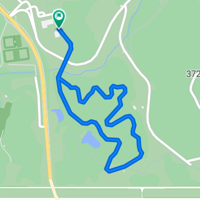
海とじゃがいもの花ルート
A cycling route starting in Takehara, Hiroshima, Japan.
Overview
About this route
- -:--
- Duration
- 14.6 km
- Distance
- 185 m
- Ascent
- 184 m
- Descent
- ---
- Avg. speed
- ---
- Max. altitude

Route quality
Waytypes & surfaces along the route
Waytypes
Quiet road
9.5 km
(65 %)
Road
4.4 km
(30 %)
Undefined
0.7 km
(5 %)
Continue with Bikemap
Use, edit, or download this cycling route
You would like to ride 海とじゃがいもの花ルート or customize it for your own trip? Here is what you can do with this Bikemap route:
Free features
- Save this route as favorite or in collections
- Copy & plan your own version of this route
- Sync your route with Garmin or Wahoo
Premium features
Free trial for 3 days, or one-time payment. More about Bikemap Premium.
- Navigate this route on iOS & Android
- Export a GPX / KML file of this route
- Create your custom printout (try it for free)
- Download this route for offline navigation
Discover more Premium features.
Get Bikemap PremiumFrom our community
Other popular routes starting in Takehara
 広島県立中央森林公園 健脚コース
- Distance
- 10 km
- Ascent
- 272 m
- Descent
- 228 m
- Location
- Takehara, Hiroshima, Japan
 De 94-22, Mihara a 1-chōme 6, Hiroshima
- Distance
- 54.6 km
- Ascent
- 639 m
- Descent
- 949 m
- Location
- Takehara, Hiroshima, Japan
 Japan 2015
- Distance
- 1,311.9 km
- Ascent
- 194 m
- Descent
- 519 m
- Location
- Takehara, Hiroshima, Japan
 Uni to Takehara
- Distance
- 24.3 km
- Ascent
- 219 m
- Descent
- 431 m
- Location
- Takehara, Hiroshima, Japan
 広島県立中央森林公園 ファミリーコースC
- Distance
- 1.7 km
- Ascent
- 36 m
- Descent
- 37 m
- Location
- Takehara, Hiroshima, Japan
 チャレンジ朝日山ルート
- Distance
- 5.9 km
- Ascent
- 444 m
- Descent
- 15 m
- Location
- Takehara, Hiroshima, Japan
 HIJ to SAIJO
- Distance
- 21.3 km
- Ascent
- 252 m
- Descent
- 362 m
- Location
- Takehara, Hiroshima, Japan
 海とじゃがいもの花ルート
- Distance
- 14.6 km
- Ascent
- 185 m
- Descent
- 184 m
- Location
- Takehara, Hiroshima, Japan
Open it in the app