

一般県道桐生足利藤岡自転車道線(渡良瀬川自転車道)
A cycling route starting in Kiryū, Gunma, Japan.
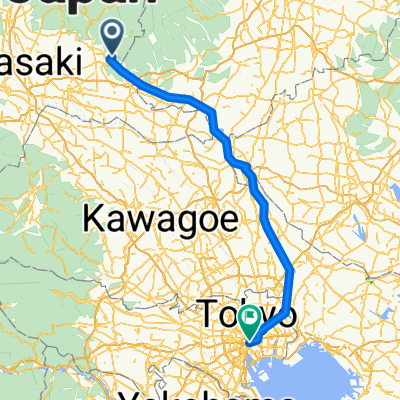
Overview
About this route
- -:--
- Duration
- 38.1 km
- Distance
- 137 m
- Ascent
- 221 m
- Descent
- ---
- Avg. speed
- ---
- Max. altitude

Route quality
Waytypes & surfaces along the route
Waytypes
Cycleway
27.8 km
(73 %)
Quiet road
3.4 km
(9 %)
Surfaces
Paved
2.7 km
(7 %)
Paved (undefined)
1.9 km
(5 %)
Asphalt
0.8 km
(2 %)
Undefined
35.4 km
(93 %)
Continue with Bikemap
Use, edit, or download this cycling route
You would like to ride 一般県道桐生足利藤岡自転車道線(渡良瀬川自転車道) or customize it for your own trip? Here is what you can do with this Bikemap route:
Free features
- Save this route as favorite or in collections
- Copy & plan your own version of this route
- Sync your route with Garmin or Wahoo
Premium features
Free trial for 3 days, or one-time payment. More about Bikemap Premium.
- Navigate this route on iOS & Android
- Export a GPX / KML file of this route
- Create your custom printout (try it for free)
- Download this route for offline navigation
Discover more Premium features.
Get Bikemap PremiumFrom our community
Other popular routes starting in Kiryū
 渡良瀬川自転車道
- Distance
- 30.5 km
- Ascent
- 8 m
- Descent
- 61 m
- Location
- Kiryū, Gunma, Japan
 Kyoto to Tokyo by the Japanese Alps
- Distance
- 2,957.2 km
- Ascent
- 5,988 m
- Descent
- 6,084 m
- Location
- Kiryū, Gunma, Japan
 Tokyo to Fukouka (LOJ)
- Distance
- 1,600.9 km
- Ascent
- 62 m
- Descent
- 150 m
- Location
- Kiryū, Gunma, Japan
 Kiryu one day
- Distance
- 58.8 km
- Ascent
- 1,580 m
- Descent
- 1,582 m
- Location
- Kiryū, Gunma, Japan
 10kmコース
- Distance
- 10.1 km
- Ascent
- 16 m
- Descent
- 68 m
- Location
- Kiryū, Gunma, Japan
 length of japan
- Distance
- 2,353.7 km
- Ascent
- 8,382 m
- Descent
- 8,489 m
- Location
- Kiryū, Gunma, Japan
 Japan
Japan- Distance
- 2,350.1 km
- Ascent
- 8,213 m
- Descent
- 8,320 m
- Location
- Kiryū, Gunma, Japan
 Japan 2
- Distance
- 2,353.7 km
- Ascent
- 8,377 m
- Descent
- 8,484 m
- Location
- Kiryū, Gunma, Japan
Open it in the app