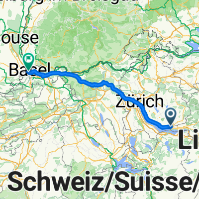
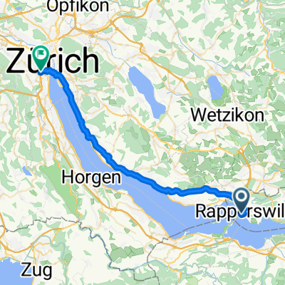
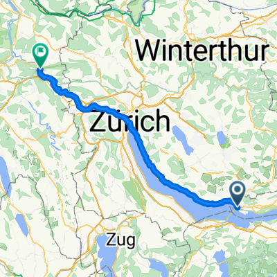
Schönbodenweg 56, Rapperswil-Jona nach Schönbodenweg 56, Rapperswil-Jona
A cycling route starting in Rapperswil, Canton of St. Gallen, Switzerland.
Overview
About this route
- 1 h 25 min
- Duration
- 26.7 km
- Distance
- 831 m
- Ascent
- 835 m
- Descent
- 18.8 km/h
- Avg. speed
- ---
- Max. altitude
Route quality
Waytypes & surfaces along the route
Waytypes
Road
11.7 km
(44 %)
Path
6.1 km
(23 %)
Surfaces
Paved
26.1 km
(98 %)
Asphalt
25.9 km
(97 %)
Concrete
0.3 km
(1 %)
Undefined
0.5 km
(2 %)
Continue with Bikemap
Use, edit, or download this cycling route
You would like to ride Schönbodenweg 56, Rapperswil-Jona nach Schönbodenweg 56, Rapperswil-Jona or customize it for your own trip? Here is what you can do with this Bikemap route:
Free features
- Save this route as favorite or in collections
- Copy & plan your own version of this route
- Sync your route with Garmin or Wahoo
Premium features
Free trial for 3 days, or one-time payment. More about Bikemap Premium.
- Navigate this route on iOS & Android
- Export a GPX / KML file of this route
- Create your custom printout (try it for free)
- Download this route for offline navigation
Discover more Premium features.
Get Bikemap PremiumFrom our community
Other popular routes starting in Rapperswil
- Schönbodenstrasse 56, Rapperswil-Jona nach Schönbodenstrasse 56, Rapperswil-Jona
- Distance
- 38.5 km
- Ascent
- 293 m
- Descent
- 293 m
- Location
- Rapperswil, Canton of St. Gallen, Switzerland
- JN 4.2 Vierwaldstädter See
- Distance
- 65.3 km
- Ascent
- 789 m
- Descent
- 776 m
- Location
- Rapperswil, Canton of St. Gallen, Switzerland
- Rapperswil-Sass da Grüm
- Distance
- 270.6 km
- Ascent
- 2,119 m
- Descent
- 2,064 m
- Location
- Rapperswil, Canton of St. Gallen, Switzerland
- Challenge Tour: Rapperswil - Feldkirch
- Distance
- 95.9 km
- Ascent
- 138 m
- Descent
- 88 m
- Location
- Rapperswil, Canton of St. Gallen, Switzerland
- Schönbodenweg 54, Rapperswil-Jona nach Schönbodenweg 54, Rapperswil-Jona
- Distance
- 31.3 km
- Ascent
- 321 m
- Descent
- 320 m
- Location
- Rapperswil, Canton of St. Gallen, Switzerland
- Kempraten-Atzmännig-Hiltisberg-Kempraten
- Distance
- 44.6 km
- Ascent
- 649 m
- Descent
- 643 m
- Location
- Rapperswil, Canton of St. Gallen, Switzerland
- Sattelegg - Ibergeregg - Zugersee
- Distance
- 117.9 km
- Ascent
- 1,857 m
- Descent
- 1,858 m
- Location
- Rapperswil, Canton of St. Gallen, Switzerland
- Rapperswil-Jona nach Rhein (Zweidlen). Neu: "Geheimer" Gleisweg Eglisau - Zweidlen (eine Verlängerung in den Schatten). Achtung: Beim Hochwasser: überflütet
- Distance
- 67.2 km
- Ascent
- 749 m
- Descent
- 803 m
- Location
- Rapperswil, Canton of St. Gallen, Switzerland
Open it in the app