
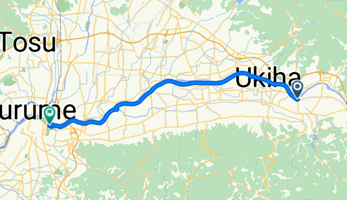
一般県道吉井久留米自転車道線(筑後川自転車道線)
A cycling route starting in Tanushimarumachi-toyoki, Fukuoka, Japan.
Overview
About this route
- -:--
- Duration
- 27.7 km
- Distance
- 40 m
- Ascent
- 67 m
- Descent
- ---
- Avg. speed
- ---
- Max. altitude

Route quality
Waytypes & surfaces along the route
Waytypes
Cycleway
26.6 km
(96 %)
Quiet road
0.6 km
(2 %)
Surfaces
Paved
0.3 km
(1 %)
Asphalt
0.3 km
(1 %)
Undefined
27.4 km
(99 %)
Continue with Bikemap
Use, edit, or download this cycling route
You would like to ride 一般県道吉井久留米自転車道線(筑後川自転車道線) or customize it for your own trip? Here is what you can do with this Bikemap route:
Free features
- Save this route as favorite or in collections
- Copy & plan your own version of this route
- Sync your route with Garmin or Wahoo
Premium features
Free trial for 3 days, or one-time payment. More about Bikemap Premium.
- Navigate this route on iOS & Android
- Export a GPX / KML file of this route
- Create your custom printout (try it for free)
- Download this route for offline navigation
Discover more Premium features.
Get Bikemap PremiumFrom our community
Other popular routes starting in Tanushimarumachi-toyoki
 385-4, Ukiha to Chikugo
- Distance
- 38.3 km
- Ascent
- 113 m
- Descent
- 130 m
- Location
- Tanushimarumachi-toyoki, Fukuoka, Japan
 301−5, 久留米市 まで301−11, 久留米市
- Distance
- 38.1 km
- Ascent
- 300 m
- Descent
- 325 m
- Location
- Tanushimarumachi-toyoki, Fukuoka, Japan
 共星の里,ラーメン屋 to 津古駅
- Distance
- 32.6 km
- Ascent
- 178 m
- Descent
- 350 m
- Location
- Tanushimarumachi-toyoki, Fukuoka, Japan
 一般県道吉井久留米自転車道線(筑後川自転車道線)
- Distance
- 27.7 km
- Ascent
- 40 m
- Descent
- 67 m
- Location
- Tanushimarumachi-toyoki, Fukuoka, Japan
 田主丸駅,志波 to 共星の里
- Distance
- 20.3 km
- Ascent
- 307 m
- Descent
- 115 m
- Location
- Tanushimarumachi-toyoki, Fukuoka, Japan
 県道740号, Kurume-Shi to 国道210号, Kurume-Shi
- Distance
- 9.7 km
- Ascent
- 31 m
- Descent
- 29 m
- Location
- Tanushimarumachi-toyoki, Fukuoka, Japan
Open it in the app