

一の宮ルート
A cycling route starting in Aso, Kumamoto, Japan.
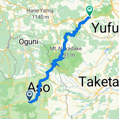
Overview
About this route
- -:--
- Duration
- 17.8 km
- Distance
- 93 m
- Ascent
- 93 m
- Descent
- ---
- Avg. speed
- ---
- Max. altitude

Route quality
Waytypes & surfaces along the route
Waytypes
Quiet road
11.2 km
(63 %)
Road
1.2 km
(7 %)
Continue with Bikemap
Use, edit, or download this cycling route
You would like to ride 一の宮ルート or customize it for your own trip? Here is what you can do with this Bikemap route:
Free features
- Save this route as favorite or in collections
- Copy & plan your own version of this route
- Sync your route with Garmin or Wahoo
Premium features
Free trial for 3 days, or one-time payment. More about Bikemap Premium.
- Navigate this route on iOS & Android
- Export a GPX / KML file of this route
- Create your custom printout (try it for free)
- Download this route for offline navigation
Discover more Premium features.
Get Bikemap PremiumFrom our community
Other popular routes starting in Aso
 aso_day1
- Distance
- 59.6 km
- Ascent
- 1,661 m
- Descent
- 1,339 m
- Location
- Aso, Kumamoto, Japan
 九州ツアー4日目
- Distance
- 93.3 km
- Ascent
- 1,399 m
- Descent
- 1,912 m
- Location
- Aso, Kumamoto, Japan
 別府一の宮線, Aso to 1483-4, Yufu
- Distance
- 115.3 km
- Ascent
- 1,241 m
- Descent
- 1,580 m
- Location
- Aso, Kumamoto, Japan
 Aso to 20-5, Yufu
- Distance
- 64.8 km
- Ascent
- 1,695 m
- Descent
- 1,769 m
- Location
- Aso, Kumamoto, Japan
 Day 5
Day 5- Distance
- 127.9 km
- Ascent
- 2,098 m
- Descent
- 2,405 m
- Location
- Aso, Kumamoto, Japan
 AsoShrine to HigoOtsu
- Distance
- 31.9 km
- Ascent
- 215 m
- Descent
- 609 m
- Location
- Aso, Kumamoto, Japan
 Cracking ride
- Distance
- 163.1 km
- Ascent
- 416 m
- Descent
- 177 m
- Location
- Aso, Kumamoto, Japan
 Aso to Yatsushiro
- Distance
- 80.9 km
- Ascent
- 217 m
- Descent
- 735 m
- Location
- Aso, Kumamoto, Japan
Open it in the app