

Architektów-Krzemionka-Architektów
A cycling route starting in Kielanówka, Subcarpathian Voivodeship, Poland.
Overview
About this route
- -:--
- Duration
- 29.6 km
- Distance
- 285 m
- Ascent
- 290 m
- Descent
- ---
- Avg. speed
- ---
- Max. altitude
Continue with Bikemap
Use, edit, or download this cycling route
You would like to ride Architektów-Krzemionka-Architektów or customize it for your own trip? Here is what you can do with this Bikemap route:
Free features
- Save this route as favorite or in collections
- Copy & plan your own version of this route
- Sync your route with Garmin or Wahoo
Premium features
Free trial for 3 days, or one-time payment. More about Bikemap Premium.
- Navigate this route on iOS & Android
- Export a GPX / KML file of this route
- Create your custom printout (try it for free)
- Download this route for offline navigation
Discover more Premium features.
Get Bikemap PremiumFrom our community
Other popular routes starting in Kielanówka
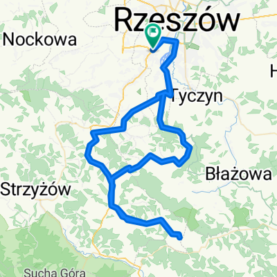 07.04.2012
- Distance
- 84.9 km
- Ascent
- 517 m
- Descent
- 517 m
- Location
- Kielanówka, Subcarpathian Voivodeship, Poland
 Architektów-Rezerwat-Siedliska-Architektow
- Distance
- 51.7 km
- Ascent
- 573 m
- Descent
- 574 m
- Location
- Kielanówka, Subcarpathian Voivodeship, Poland
 Kielanówka-Boguchwała-Czudec-Nawsie-Wielopole-Zagórzyce-Sędziszów-Zgłobień-Kielanówka
- Distance
- 85.5 km
- Ascent
- 417 m
- Descent
- 489 m
- Location
- Kielanówka, Subcarpathian Voivodeship, Poland
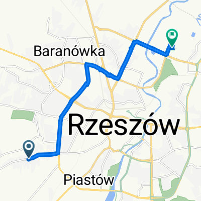 Staroniwska 73, Rzeszów do Ciepłownicza 8B, Rzeszów
- Distance
- 8 km
- Ascent
- 30 m
- Descent
- 64 m
- Location
- Kielanówka, Subcarpathian Voivodeship, Poland
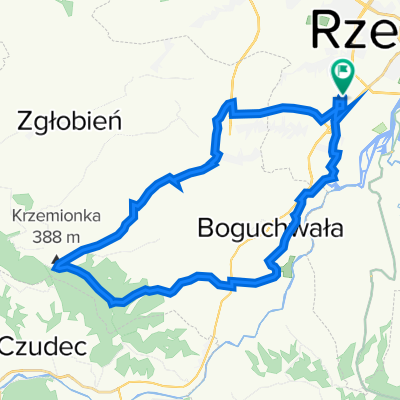 Architektów-Krzemionka-Architektów
- Distance
- 29.6 km
- Ascent
- 285 m
- Descent
- 290 m
- Location
- Kielanówka, Subcarpathian Voivodeship, Poland
 Bike trial Rzeszow-Czudec-Rzeszow MTB; mostly off road 1 maj
- Distance
- 54.5 km
- Ascent
- 569 m
- Descent
- 605 m
- Location
- Kielanówka, Subcarpathian Voivodeship, Poland
 2013/11 Rzeszów Kresowa - Niechobrz Górny
- Distance
- 24.8 km
- Ascent
- 244 m
- Descent
- 245 m
- Location
- Kielanówka, Subcarpathian Voivodeship, Poland
 Makowa 2, Rzeszów do Ciepłownicza 8B, Rzeszów
- Distance
- 8.1 km
- Ascent
- 36 m
- Descent
- 74 m
- Location
- Kielanówka, Subcarpathian Voivodeship, Poland
Open it in the app