

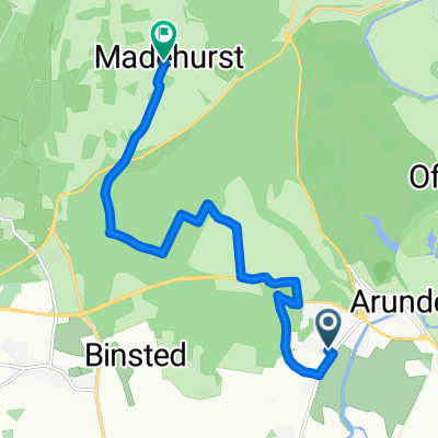
The Causeway 415 to George Byng Way
A cycling route starting in Arundel, England, United Kingdom.
Overview
About this route
- -:--
- Duration
- 54.3 km
- Distance
- 39 m
- Ascent
- 38 m
- Descent
- ---
- Avg. speed
- ---
- Max. altitude

Route quality
Waytypes & surfaces along the route
Waytypes
Cycleway
27.7 km
(51 %)
Road
12.5 km
(23 %)
Surfaces
Paved
43.4 km
(80 %)
Asphalt
42.9 km
(79 %)
Metal
0.5 km
(1 %)
Undefined
10.9 km
(20 %)
Continue with Bikemap
Use, edit, or download this cycling route
You would like to ride The Causeway 415 to George Byng Way or customize it for your own trip? Here is what you can do with this Bikemap route:
Free features
- Save this route as favorite or in collections
- Copy & plan your own version of this route
- Sync your route with Garmin or Wahoo
Premium features
Free trial for 3 days, or one-time payment. More about Bikemap Premium.
- Navigate this route on iOS & Android
- Export a GPX / KML file of this route
- Create your custom printout (try it for free)
- Download this route for offline navigation
Discover more Premium features.
Get Bikemap PremiumFrom our community
Other popular routes starting in Arundel
 Houghton & Eartham Woods
- Distance
- 28.3 km
- Ascent
- 447 m
- Descent
- 447 m
- Location
- Arundel, England, United Kingdom
 Training Route : -) Bury 23er - Bury - Amberley - Greatham - Coates - West Burton - Bury
- Distance
- 23.1 km
- Ascent
- 185 m
- Descent
- 188 m
- Location
- Arundel, England, United Kingdom
 Stewards Rise, Arundel to Madehurst Lodge, Arundel
- Distance
- 9.5 km
- Ascent
- 168 m
- Descent
- 104 m
- Location
- Arundel, England, United Kingdom
 Arundel - Totland Bay
- Distance
- 112 km
- Ascent
- 317 m
- Descent
- 293 m
- Location
- Arundel, England, United Kingdom
 trasa dla dominika cz 1
- Distance
- 38.2 km
- Ascent
- 609 m
- Descent
- 421 m
- Location
- Arundel, England, United Kingdom
 Bury Reverse 52er
- Distance
- 52.1 km
- Ascent
- 325 m
- Descent
- 323 m
- Location
- Arundel, England, United Kingdom
 Bury 52er
- Distance
- 51.9 km
- Ascent
- 354 m
- Descent
- 352 m
- Location
- Arundel, England, United Kingdom
 Recording from 31 jul. 2017 13:08
- Distance
- 6.8 km
- Ascent
- 148 m
- Descent
- 180 m
- Location
- Arundel, England, United Kingdom
Open it in the app