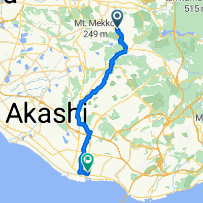
一般県道神出山田自転車道線(神出山田自転車道)
A cycling route starting in Miki, Hyōgo, Japan.
Overview
About this route
- -:--
- Duration
- 18.4 km
- Distance
- 294 m
- Ascent
- 242 m
- Descent
- ---
- Avg. speed
- ---
- Avg. speed
Route quality
Waytypes & surfaces along the route
Waytypes
Cycleway
13.5 km
(74 %)
Quiet road
2.6 km
(14 %)
Surfaces
Paved
1.9 km
(10 %)
Paved (undefined)
1.3 km
(7 %)
Asphalt
0.6 km
(3 %)
Undefined
16.5 km
(90 %)
Continue with Bikemap
Use, edit, or download this cycling route
You would like to ride 一般県道神出山田自転車道線(神出山田自転車道) or customize it for your own trip? Here is what you can do with this Bikemap route:
Free features
- Save this route as favorite or in collections
- Copy & plan your own version of this route
- Sync your route with Garmin or Wahoo
Premium features
Free trial for 3 days, or one-time payment. More about Bikemap Premium.
- Navigate this route on iOS & Android
- Export a GPX / KML file of this route
- Create your custom printout (try it for free)
- Download this route for offline navigation
Discover more Premium features.
Get Bikemap PremiumFrom our community
Other popular routes starting in Miki
- 志染町, 三木市 to 桂木2丁目10-8, 神戸市北区
- Distance
- 20.7 km
- Ascent
- 503 m
- Descent
- 367 m
- Location
- Miki, Hyōgo, Japan
- 1丁目, 神戸市 to 高和, 神戸市
- Distance
- 28.9 km
- Ascent
- 303 m
- Descent
- 259 m
- Location
- Miki, Hyōgo, Japan
- 1673, Kandecho Hosei, Nishi-Ku, Kobe-Shi to 国道175号, Nishi-Ku, Kobe-Shi
- Distance
- 3.1 km
- Ascent
- 23 m
- Descent
- 0 m
- Location
- Miki, Hyōgo, Japan
- Oka, Inami-Cho, Kako-Gun to Kitayama, Inami-Cho, Kako-Gun
- Distance
- 15.7 km
- Ascent
- 84 m
- Descent
- 99 m
- Location
- Miki, Hyōgo, Japan
- 1544-2, Iwaokacho Iwaoka, Nishi-Ku, Kobe-Shi to Kandecho Hosei, Nishi-Ku, Kobe-Shi
- Distance
- 1.9 km
- Ascent
- 13 m
- Descent
- 3 m
- Location
- Miki, Hyōgo, Japan
- 1905, Kandecho Hosei, Nishi-Ku, Kobe-Shi to 1651-4, Kandecho Hosei, Nishi-Ku, Kobe-Shi
- Distance
- 0.5 km
- Ascent
- 3 m
- Descent
- 0 m
- Location
- Miki, Hyōgo, Japan
- がやいん 帰り
- Distance
- 24.9 km
- Ascent
- 401 m
- Descent
- 433 m
- Location
- Miki, Hyōgo, Japan
- 淡河ー丹波篠山
- Distance
- 137.8 km
- Ascent
- 2,900 m
- Descent
- 2,900 m
- Location
- Miki, Hyōgo, Japan
Open it in the app