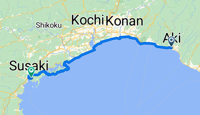
パシフィックオーシャンロード
A cycling route starting in Aki, Kochi, Japan.
Overview
About this route
- -:--
- Duration
- 79.4 km
- Distance
- 1,216 m
- Ascent
- 1,214 m
- Descent
- ---
- Avg. speed
- ---
- Max. altitude
Route quality
Waytypes & surfaces along the route
Waytypes
Quiet road
19.1 km
(24 %)
Cycleway
7.9 km
(10 %)
Surfaces
Paved
0.8 km
(1 %)
Asphalt
0.8 km
(1 %)
Undefined
78.6 km
(99 %)
Continue with Bikemap
Use, edit, or download this cycling route
You would like to ride パシフィックオーシャンロード or customize it for your own trip? Here is what you can do with this Bikemap route:
Free features
- Save this route as favorite or in collections
- Copy & plan your own version of this route
- Sync your route with Garmin or Wahoo
Premium features
Free trial for 3 days, or one-time payment. More about Bikemap Premium.
- Navigate this route on iOS & Android
- Export a GPX / KML file of this route
- Create your custom printout (try it for free)
- Download this route for offline navigation
Discover more Premium features.
Get Bikemap PremiumFrom our community
Other popular routes starting in Aki
- 180320_高知
- Distance
- 66.8 km
- Ascent
- 2,019 m
- Descent
- 2,025 m
- Location
- Aki, Kochi, Japan
- shikoku finale 28.09.2019
- Distance
- 60.9 km
- Ascent
- 142 m
- Descent
- 146 m
- Location
- Aki, Kochi, Japan
- 298-12, Konan to Konan
- Distance
- 1 km
- Ascent
- 7 m
- Descent
- 34 m
- Location
- Aki, Kochi, Japan
- Yasuchō Tei, Konan to Konan
- Distance
- 2.3 km
- Ascent
- 0 m
- Descent
- 54 m
- Location
- Aki, Kochi, Japan
- shikoku trip day8
- Distance
- 44.7 km
- Ascent
- 122 m
- Descent
- 123 m
- Location
- Aki, Kochi, Japan
- Yasuchō Tei, Konan to 1930-1, Konan
- Distance
- 6.3 km
- Ascent
- 20 m
- Descent
- 64 m
- Location
- Aki, Kochi, Japan
- Tano toyo
- Distance
- 48.1 km
- Ascent
- 1,106 m
- Descent
- 1,104 m
- Location
- Aki, Kochi, Japan
- ゆずの里と慎太郎コース
- Distance
- 66.9 km
- Ascent
- 2,277 m
- Descent
- 2,278 m
- Location
- Aki, Kochi, Japan
Open it in the app