

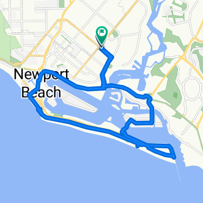
Ventura to SD Day 3
A cycling route starting in Costa Mesa, California, United States.
Overview
About this route
- -:--
- Duration
- 138.4 km
- Distance
- 943 m
- Ascent
- 857 m
- Descent
- ---
- Avg. speed
- ---
- Max. altitude
Continue with Bikemap
Use, edit, or download this cycling route
You would like to ride Ventura to SD Day 3 or customize it for your own trip? Here is what you can do with this Bikemap route:
Free features
- Save this route as favorite or in collections
- Copy & plan your own version of this route
- Split it into stages to create a multi-day tour
- Sync your route with Garmin or Wahoo
Premium features
Free trial for 3 days, or one-time payment. More about Bikemap Premium.
- Navigate this route on iOS & Android
- Export a GPX / KML file of this route
- Create your custom printout (try it for free)
- Download this route for offline navigation
Discover more Premium features.
Get Bikemap PremiumFrom our community
Other popular routes starting in Costa Mesa
 Newport Back Bay
- Distance
- 20.8 km
- Ascent
- 164 m
- Descent
- 164 m
- Location
- Costa Mesa, California, United States
 West 19th Street 960, Costa Mesa to West 19th Street 960, Costa Mesa
- Distance
- 29.2 km
- Ascent
- 236 m
- Descent
- 237 m
- Location
- Costa Mesa, California, United States
 West 19th Street 960, Costa Mesa to West 19th Street 960, Costa Mesa
- Distance
- 25.8 km
- Ascent
- 107 m
- Descent
- 106 m
- Location
- Costa Mesa, California, United States
 San Joaquin Hills Rd, Newport Beach to San Joaquin Hills Rd, Newport Beach
- Distance
- 52.4 km
- Ascent
- 3 m
- Descent
- 14 m
- Location
- Costa Mesa, California, United States
 Lengthy bike tour from Costa Mesa to Fountain Valley
- Distance
- 30.3 km
- Ascent
- 64 m
- Descent
- 64 m
- Location
- Costa Mesa, California, United States
 Back Bay to Dana Point
- Distance
- 47.8 km
- Ascent
- 420 m
- Descent
- 418 m
- Location
- Costa Mesa, California, United States
 Irvine Ave, Newport Beach to Irvine Ave, Newport Beach
- Distance
- 19.5 km
- Ascent
- 77 m
- Descent
- 68 m
- Location
- Costa Mesa, California, United States
 Santiago Canyon loop
- Distance
- 84.4 km
- Ascent
- 527 m
- Descent
- 524 m
- Location
- Costa Mesa, California, United States
Open it in the app