- 50.8 km
- 660 m
- 613 m
- Le Plan-de-la-Tour, Provence-Alpes-C么te d'Azur Region, France
Le Plan de la Tour, 27 km
A cycling route starting in Le Plan-de-la-Tour, Provence-Alpes-C么te d'Azur Region, France.OverviewAbout this route
The start and end point is Le Plan de la Tour, a beautiful place in Provence, 10 km from the sea. The first 6 km are all uphill on a first-class road. Car traffic tends toward zero. From there begins an off-road section of about 10 km. Halfway through, two large sheepdogs blocked my way forward. They started to circle me. Fortunately, I had my panic alarm with me. It saved my a**. They really didn't like the shrill sound and fled. Unfortunately, I then had a flat tire. So always carry a repair kit. The remaining 11 km were back on super smooth asphalt with no car traffic at all.
- -:--
- Duration
- 25.7 km
- Distance
- 551 m
- Ascent
- 550 m
- Descent
- ---
- Avg. speed
- ---
- Max. altitude
Heinzcreated this 6 years ago
Route qualityWaytypes & surfaces along the route
Waytypes
Track
8.7 km34 %Road
5.4 km21 %
Surfaces
Paved
16.4 km(64 %)Unpaved
1 km(4 %)Asphalt
16.4 km64 %Gravel
1 km4 %Undefined
8.2 km32 %
Free features
- Save this route as favorite or in collections
- Copy & plan your own version of this route
- Sync your route with Garmin or Wahoo
Premium features
Free trial for 3 days, or one-time payment. More about Bikemap Premium.
- Navigate this route on iOS & Android
- Export a GPX / KML file of this route
- Create your custom printout (try it for free)
- Download this route for offline navigation
Discover more Premium features.
Get Bikemap Premium- 
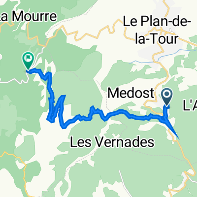
Plan de la Tour-Salernes
- P1-Le plan de la tour-Salernes
- 50.2 km
- 655 m
- 512 m
- Le Plan-de-la-Tour, Provence-Alpes-C么te d'Azur Region, France
- Plan de la tour d72
- 41.4 km
- 551 m
- 555 m
- Le Plan-de-la-Tour, Provence-Alpes-C么te d'Azur Region, France
- 83 Coriolan, Le Plan-de-la-Tour 脿 15 Chemin de la Galline, La Garde-Freinet
- 10.1 km
- 338 m
- 142 m
- Le Plan-de-la-Tour, Provence-Alpes-C么te d'Azur Region, France
- Massif des Maures 6
- 37.4 km
- 570 m
- 567 m
- Le Plan-de-la-Tour, Provence-Alpes-C么te d'Azur Region, France
- 210 Chemin de l'Aire du Pin, Le Plan-de-la-Tour nach D559, Sainte-Maxime
- 9.8 km
- 10 m
- 82 m
- Le Plan-de-la-Tour, Provence-Alpes-C么te d'Azur Region, France
- 52 Chemin de Sigallas, Le Plan-de-la-Tour nach Chemin des Cr锚tes, Le Plan-de-la-Tour
- 4.8 km
- 94 m
- 36 m
- Le Plan-de-la-Tour, Provence-Alpes-C么te d'Azur Region, France
- Chemin de Prat-Bourdin, Le Plan-de-la-Tour 脿 83 Coriolan, Le Plan-de-la-Tour
- 3.1 km
- 112 m
- 26 m
- Le Plan-de-la-Tour, Provence-Alpes-C么te d'Azur Region, France
Open it in the app


