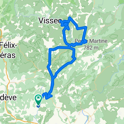
Mont Saint Baudille 2023
- 60 km
- 1,790 m
- 1,790 m
- Montpeyroux, Occitanie, France
A cycling route starting in Montpeyroux, Occitanie, France.
Overview
created this 5 years ago
Route quality
Track
25.3 km
(81 %)
Quiet road
2.8 km
(9 %)
Paved
2.2 km
(7 %)
Unpaved
25.9 km
(83 %)
Gravel
22.5 km
(72 %)
Asphalt
2.2 km
(7 %)
Continue with Bikemap
You would like to ride Etape 07 – De La Font du Griffe à La Vernède or customize it for your own trip? Here is what you can do with this Bikemap route:
Free trial for 3 days, or one-time payment. More about Bikemap Premium.
Discover more Premium features.
Get Bikemap PremiumFrom our community
Open it in the app