

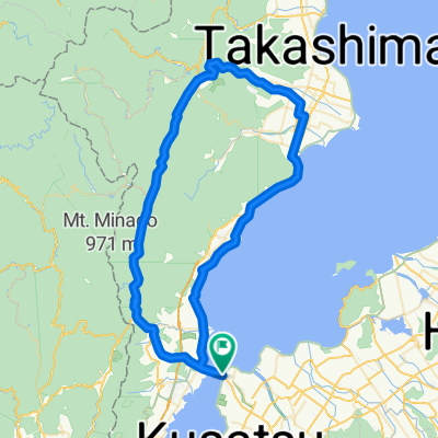
一般県道守山大津志賀自転車道線(びわ湖レイクサイド自転車道)
A cycling route starting in Kitahama, Shiga Prefecture, Japan.
Overview
About this route
- -:--
- Duration
- 21.2 km
- Distance
- 42 m
- Ascent
- 36 m
- Descent
- ---
- Avg. speed
- ---
- Max. altitude

Route quality
Waytypes & surfaces along the route
Waytypes
Cycleway
5.5 km
(26 %)
Quiet road
1.9 km
(9 %)
Surfaces
Paved
11.9 km
(56 %)
Asphalt
11.2 km
(53 %)
Paved (undefined)
0.6 km
(3 %)
Undefined
9.3 km
(44 %)
Continue with Bikemap
Use, edit, or download this cycling route
You would like to ride 一般県道守山大津志賀自転車道線(びわ湖レイクサイド自転車道) or customize it for your own trip? Here is what you can do with this Bikemap route:
Free features
- Save this route as favorite or in collections
- Copy & plan your own version of this route
- Sync your route with Garmin or Wahoo
Premium features
Free trial for 3 days, or one-time payment. More about Bikemap Premium.
- Navigate this route on iOS & Android
- Export a GPX / KML file of this route
- Create your custom printout (try it for free)
- Download this route for offline navigation
Discover more Premium features.
Get Bikemap PremiumFrom our community
Other popular routes starting in Kitahama
 Biwa Part 1
- Distance
- 150.9 km
- Ascent
- 242 m
- Descent
- 227 m
- Location
- Kitahama, Shiga Prefecture, Japan
 国道477号, 守山市へ国道477号, 守山市
- Distance
- 80.6 km
- Ascent
- 1,008 m
- Descent
- 1,004 m
- Location
- Kitahama, Shiga Prefecture, Japan
 志賀駅, 大津市 to 志賀駅, 大津市
- Distance
- 148.3 km
- Ascent
- 131 m
- Descent
- 168 m
- Location
- Kitahama, Shiga Prefecture, Japan
 今浜町, 守山市 to 新浜町440-1, 草津市
- Distance
- 170.5 km
- Ascent
- 924 m
- Descent
- 921 m
- Location
- Kitahama, Shiga Prefecture, Japan
 2876-1, Imahamacho, Moriyama-Shi to Sazanami-kaido Street, Moriyama-Shi
- Distance
- 70 km
- Ascent
- 648 m
- Descent
- 648 m
- Location
- Kitahama, Shiga Prefecture, Japan
 白鬚神舍,宇治橋,平等院,京都車站。
- Distance
- 68.6 km
- Ascent
- 236 m
- Descent
- 295 m
- Location
- Kitahama, Shiga Prefecture, Japan
 Biwa Part 1
- Distance
- 75.7 km
- Ascent
- 204 m
- Descent
- 203 m
- Location
- Kitahama, Shiga Prefecture, Japan
 From hostel to Shirahige Shrine
- Distance
- 8 km
- Ascent
- 21 m
- Descent
- 20 m
- Location
- Kitahama, Shiga Prefecture, Japan
Open it in the app