

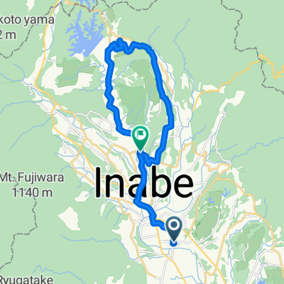
大自然コース
A cycling route starting in Komono, Mie, Japan.
Overview
About this route
- -:--
- Duration
- 24.5 km
- Distance
- 437 m
- Ascent
- 440 m
- Descent
- ---
- Avg. speed
- ---
- Max. altitude

Continue with Bikemap
Use, edit, or download this cycling route
You would like to ride 大自然コース or customize it for your own trip? Here is what you can do with this Bikemap route:
Free features
- Save this route as favorite or in collections
- Copy & plan your own version of this route
- Sync your route with Garmin or Wahoo
Premium features
Free trial for 3 days, or one-time payment. More about Bikemap Premium.
- Navigate this route on iOS & Android
- Export a GPX / KML file of this route
- Create your custom printout (try it for free)
- Download this route for offline navigation
Discover more Premium features.
Get Bikemap PremiumFrom our community
Other popular routes starting in Komono
 Inabe - Inuyama
- Distance
- 80.4 km
- Ascent
- 492 m
- Descent
- 497 m
- Location
- Komono, Mie, Japan
 TOJコース
- Distance
- 20.1 km
- Ascent
- 247 m
- Descent
- 218 m
- Location
- Komono, Mie, Japan
 サイクルパスコース
- Distance
- 13.1 km
- Ascent
- 73 m
- Descent
- 169 m
- Location
- Komono, Mie, Japan
 【三重県】ルートラボで見る2018ツアー・オブ・ジャパン 第3ステージコースと沿線の街々を紹介
- Distance
- 25.9 km
- Ascent
- 414 m
- Descent
- 301 m
- Location
- Komono, Mie, Japan
 to Kyoto
- Distance
- 99.4 km
- Ascent
- 1,397 m
- Descent
- 1,477 m
- Location
- Komono, Mie, Japan
 Hokuseichoshimmachi, Inabe to 2-2, Kinjofuto 3-Chōme, Minato, Nagoya
- Distance
- 44.3 km
- Ascent
- 103 m
- Descent
- 276 m
- Location
- Komono, Mie, Japan
 421, Shukuno, Komono, Mie-Gun to 1795-1, Yamamotocho, Suzuka
- Distance
- 17 km
- Ascent
- 95 m
- Descent
- 129 m
- Location
- Komono, Mie, Japan
 国道477号, 三重郡菰野町 to 内池920-3, 蒲生郡日野町
- Distance
- 37.7 km
- Ascent
- 1,105 m
- Descent
- 1,060 m
- Location
- Komono, Mie, Japan
Open it in the app