

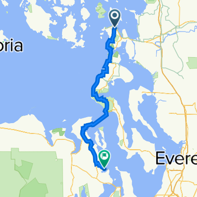
Sep16: Anacortes, WA to Fort Townsend, WA
A cycling route starting in Anacortes, Washington, United States.
Overview
About this route
Places to camp:
Fort Townsend Historical State Park ($10 fee)
- -:--
- Duration
- 82.9 km
- Distance
- 530 m
- Ascent
- 467 m
- Descent
- ---
- Avg. speed
- ---
- Max. altitude
Route quality
Waytypes & surfaces along the route
Waytypes
Road
52.2 km
(63 %)
Cycleway
9.9 km
(12 %)
Surfaces
Paved
37.3 km
(45 %)
Unpaved
3.3 km
(4 %)
Asphalt
36.5 km
(44 %)
Unpaved (undefined)
2.5 km
(3 %)
Continue with Bikemap
Use, edit, or download this cycling route
You would like to ride Sep16: Anacortes, WA to Fort Townsend, WA or customize it for your own trip? Here is what you can do with this Bikemap route:
Free features
- Save this route as favorite or in collections
- Copy & plan your own version of this route
- Split it into stages to create a multi-day tour
- Sync your route with Garmin or Wahoo
Premium features
Free trial for 3 days, or one-time payment. More about Bikemap Premium.
- Navigate this route on iOS & Android
- Export a GPX / KML file of this route
- Create your custom printout (try it for free)
- Download this route for offline navigation
Discover more Premium features.
Get Bikemap PremiumFrom our community
Other popular routes starting in Anacortes
 therapy ride
- Distance
- 29.1 km
- Ascent
- 0 m
- Descent
- 10 m
- Location
- Anacortes, Washington, United States
 BayView-Rexville-LaConnerLoop
- Distance
- 55.9 km
- Ascent
- 188 m
- Descent
- 187 m
- Location
- Anacortes, Washington, United States
 Mount Erie Route
- Distance
- 32.8 km
- Ascent
- 669 m
- Descent
- 668 m
- Location
- Anacortes, Washington, United States
 Anacortes with loop
- Distance
- 62 km
- Ascent
- 561 m
- Descent
- 562 m
- Location
- Anacortes, Washington, United States
 Fidalgo Island Pass Lake 20 mile loop
- Distance
- 34.1 km
- Ascent
- 404 m
- Descent
- 404 m
- Location
- Anacortes, Washington, United States
 anacortes to keystone ferry
- Distance
- 63.5 km
- Ascent
- 557 m
- Descent
- 633 m
- Location
- Anacortes, Washington, United States
 March's Point Park n Ride to WA Park return
- Distance
- 31.2 km
- Ascent
- 266 m
- Descent
- 266 m
- Location
- Anacortes, Washington, United States
 Anacortes to Port Ludlow
- Distance
- 94.7 km
- Ascent
- 1,330 m
- Descent
- 1,317 m
- Location
- Anacortes, Washington, United States
Open it in the app