

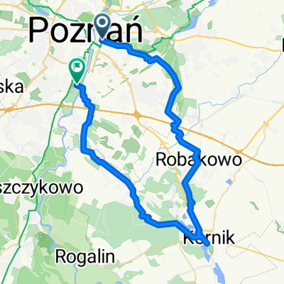
Malta - Gruszczyn - Malta (jeziora)
A cycling route starting in Poznan, Greater Poland Voivodeship, Poland.
Overview
About this route
Część trasy asfaltem, większość przez las. Droga przez las raczej dla roweru górskiego, niż miejskiego. Można jechać z dzieckiem, jest kawałek ulicą, ale jest bezpieczny chodnik, a ulica o małym ruchu. Przejście pod Warszawską (DK92) nie jest przystosowane dla rowerów. Dziecko samo może sobie nie poradzić z schodami.
Jadąc z dzieckiem trzeba wziąć pod uwagę odległość i możliwości młodego kolarza. Czasem lepiej trase podzielić na 2 częśći.
- 1 h 38 min
- Duration
- 25.5 km
- Distance
- 103 m
- Ascent
- 103 m
- Descent
- 15.6 km/h
- Avg. speed
- ---
- Max. altitude

Route quality
Waytypes & surfaces along the route
Waytypes
Path
8.7 km
(34 %)
Pedestrian area
4.6 km
(18 %)
Surfaces
Paved
7.9 km
(31 %)
Unpaved
4.1 km
(16 %)
Asphalt
6.4 km
(25 %)
Ground
2.6 km
(10 %)
Continue with Bikemap
Use, edit, or download this cycling route
You would like to ride Malta - Gruszczyn - Malta (jeziora) or customize it for your own trip? Here is what you can do with this Bikemap route:
Free features
- Save this route as favorite or in collections
- Copy & plan your own version of this route
- Sync your route with Garmin or Wahoo
Premium features
Free trial for 3 days, or one-time payment. More about Bikemap Premium.
- Navigate this route on iOS & Android
- Export a GPX / KML file of this route
- Create your custom printout (try it for free)
- Download this route for offline navigation
Discover more Premium features.
Get Bikemap PremiumFrom our community
Other popular routes starting in Poznan
 Poznań Rataje Mosina j.góreckie Puszczykowo poznań
- Distance
- 53.9 km
- Ascent
- 136 m
- Descent
- 137 m
- Location
- Poznan, Greater Poland Voivodeship, Poland
 Coffee ride do Kórnika
- Distance
- 50.1 km
- Ascent
- 205 m
- Descent
- 204 m
- Location
- Poznan, Greater Poland Voivodeship, Poland
 Ogrody ... Koziegłowy - Czerownak - Owińska - Bolechowo - Biedrusko - Radojewo - Umultowo - Naramowice ... Ogrody (revers)
- Distance
- 45.5 km
- Ascent
- 216 m
- Descent
- 214 m
- Location
- Poznan, Greater Poland Voivodeship, Poland
 Lasek Marceliński
- Distance
- 16.1 km
- Ascent
- 30 m
- Descent
- 31 m
- Location
- Poznan, Greater Poland Voivodeship, Poland
 AC-Promno-AC
- Distance
- 59.4 km
- Ascent
- 153 m
- Descent
- 154 m
- Location
- Poznan, Greater Poland Voivodeship, Poland
 POZNAŃ centrum - Jez, Maltańskie - Darzybór - Spławie - Krzesiny, Spyniewo - Głuszyna - Marlewo - Poznań Centrum
- Distance
- 40.8 km
- Ascent
- 77 m
- Descent
- 77 m
- Location
- Poznan, Greater Poland Voivodeship, Poland
 Runda Cityzen - Lusowo (plaża) - Cityzen
- Distance
- 52.6 km
- Ascent
- 46 m
- Descent
- 43 m
- Location
- Poznan, Greater Poland Voivodeship, Poland
 Rokietnica
- Distance
- 46.7 km
- Ascent
- 130 m
- Descent
- 131 m
- Location
- Poznan, Greater Poland Voivodeship, Poland
Open it in the app