
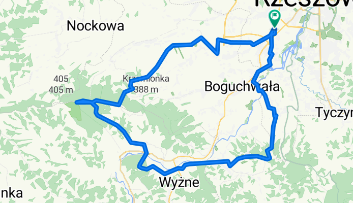
Architektów-Rezerwat-Siedliska-Architektow
A cycling route starting in Kielanówka, Subcarpathian Voivodeship, Poland.
Overview
About this route
Architektów-Rezerwat-Czudec-GóraZamkowa-Siedliska-KładkaWisłok-Architektów
- -:--
- Duration
- 51.7 km
- Distance
- 573 m
- Ascent
- 574 m
- Descent
- ---
- Avg. speed
- ---
- Max. altitude
Route quality
Waytypes & surfaces along the route
Waytypes
Quiet road
24.3 km
(47 %)
Road
10.8 km
(21 %)
Surfaces
Paved
35 km
(68 %)
Unpaved
5.9 km
(11 %)
Asphalt
33.7 km
(65 %)
Pebblestone
2.9 km
(6 %)
Continue with Bikemap
Use, edit, or download this cycling route
You would like to ride Architektów-Rezerwat-Siedliska-Architektow or customize it for your own trip? Here is what you can do with this Bikemap route:
Free features
- Save this route as favorite or in collections
- Copy & plan your own version of this route
- Sync your route with Garmin or Wahoo
Premium features
Free trial for 3 days, or one-time payment. More about Bikemap Premium.
- Navigate this route on iOS & Android
- Export a GPX / KML file of this route
- Create your custom printout (try it for free)
- Download this route for offline navigation
Discover more Premium features.
Get Bikemap PremiumFrom our community
Other popular routes starting in Kielanówka
 04.03.2012
- Distance
- 93.7 km
- Ascent
- 323 m
- Descent
- 323 m
- Location
- Kielanówka, Subcarpathian Voivodeship, Poland
 Architektów-Rezerwat-Siedliska-Architektow
- Distance
- 51.7 km
- Ascent
- 573 m
- Descent
- 574 m
- Location
- Kielanówka, Subcarpathian Voivodeship, Poland
 Trasa na sobote
- Distance
- 90.4 km
- Ascent
- 1,184 m
- Descent
- 1,183 m
- Location
- Kielanówka, Subcarpathian Voivodeship, Poland
 Bike trial Rzeszow-Czudec-Rzeszow MTB; mostly off road 1 maj
- Distance
- 54.5 km
- Ascent
- 569 m
- Descent
- 605 m
- Location
- Kielanówka, Subcarpathian Voivodeship, Poland
 Boguchwała, Lutoryż i las Lutoryski
- Distance
- 30.5 km
- Ascent
- 316 m
- Descent
- 316 m
- Location
- Kielanówka, Subcarpathian Voivodeship, Poland
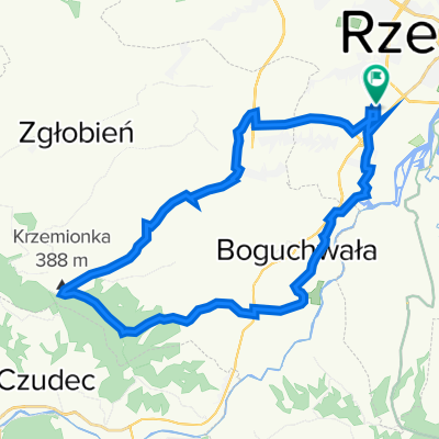 Architektów-Krzemionka-Architektów
- Distance
- 29.6 km
- Ascent
- 285 m
- Descent
- 290 m
- Location
- Kielanówka, Subcarpathian Voivodeship, Poland
 Szlak rowerowy (Błękitna pętla) - kolor niebieski
- Distance
- 23.4 km
- Ascent
- 198 m
- Descent
- 246 m
- Location
- Kielanówka, Subcarpathian Voivodeship, Poland
 2013/11 Rzeszów Kresowa - Niechobrz Górny
- Distance
- 24.8 km
- Ascent
- 244 m
- Descent
- 245 m
- Location
- Kielanówka, Subcarpathian Voivodeship, Poland
Open it in the app