

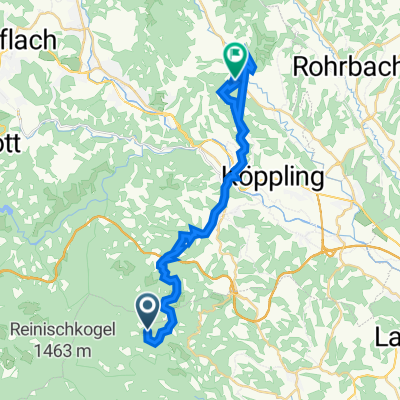
Stainzertour
A cycling route starting in Greisdorf, Styria, Austria.
Overview
About this route
- -:--
- Duration
- 53.9 km
- Distance
- 416 m
- Ascent
- 416 m
- Descent
- ---
- Avg. speed
- ---
- Max. altitude

Route quality
Waytypes & surfaces along the route
Waytypes
Quiet road
28.1 km
(52 %)
Busy road
15.3 km
(28 %)
Surfaces
Paved
16 km
(30 %)
Unpaved
2.5 km
(5 %)
Asphalt
16 km
(30 %)
Gravel
2.5 km
(5 %)
Undefined
35.4 km
(66 %)
Continue with Bikemap
Use, edit, or download this cycling route
You would like to ride Stainzertour or customize it for your own trip? Here is what you can do with this Bikemap route:
Free features
- Save this route as favorite or in collections
- Copy & plan your own version of this route
- Sync your route with Garmin or Wahoo
Premium features
Free trial for 3 days, or one-time payment. More about Bikemap Premium.
- Navigate this route on iOS & Android
- Export a GPX / KML file of this route
- Create your custom printout (try it for free)
- Download this route for offline navigation
Discover more Premium features.
Get Bikemap PremiumFrom our community
Other popular routes starting in Greisdorf
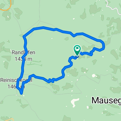 Reinischkogel Rundweg
- Distance
- 15 km
- Ascent
- 550 m
- Descent
- 550 m
- Location
- Greisdorf, Styria, Austria
 zu Ingrid
- Distance
- 16.1 km
- Ascent
- 266 m
- Descent
- 467 m
- Location
- Greisdorf, Styria, Austria
 Sommereben 17, St. Stefan nach Marktplatz 2, Stallhofen
- Distance
- 27.3 km
- Ascent
- 1,689 m
- Descent
- 2,324 m
- Location
- Greisdorf, Styria, Austria
 Preißberg 55, Wald in der Weststeiermark nach Preißberg 55, Wald in der Weststeiermark
- Distance
- 0 km
- Ascent
- 0 m
- Descent
- 0 m
- Location
- Greisdorf, Styria, Austria
 Stainzertour
- Distance
- 53.9 km
- Ascent
- 416 m
- Descent
- 416 m
- Location
- Greisdorf, Styria, Austria
 Moderate Route in
- Distance
- 7.2 km
- Ascent
- 52 m
- Descent
- 525 m
- Location
- Greisdorf, Styria, Austria
 Štýrské vinohrady 2011 - den první
- Distance
- 42.7 km
- Ascent
- 413 m
- Descent
- 659 m
- Location
- Greisdorf, Styria, Austria
 Klugbauer Aiblwirt
- Distance
- 9.5 km
- Ascent
- 305 m
- Descent
- 310 m
- Location
- Greisdorf, Styria, Austria
Open it in the app