

森林浴+MTBつちのこコース
A cycling route starting in Ikata-chō, Ehime, Japan.
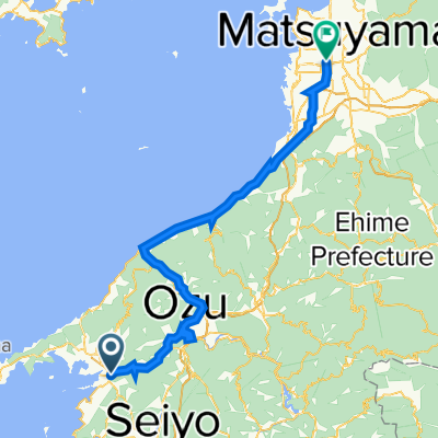
Overview
About this route
- -:--
- Duration
- 18.7 km
- Distance
- 570 m
- Ascent
- 571 m
- Descent
- ---
- Avg. speed
- ---
- Max. altitude

Route quality
Waytypes & surfaces along the route
Waytypes
Busy road
9.3 km
(50 %)
Quiet road
5.9 km
(32 %)
Continue with Bikemap
Use, edit, or download this cycling route
You would like to ride 森林浴+MTBつちのこコース or customize it for your own trip? Here is what you can do with this Bikemap route:
Free features
- Save this route as favorite or in collections
- Copy & plan your own version of this route
- Sync your route with Garmin or Wahoo
Premium features
Free trial for 3 days, or one-time payment. More about Bikemap Premium.
- Navigate this route on iOS & Android
- Export a GPX / KML file of this route
- Create your custom printout (try it for free)
- Download this route for offline navigation
Discover more Premium features.
Get Bikemap PremiumFrom our community
Other popular routes starting in Ikata-chō
 yawamahata-ouz-matsuyama
- Distance
- 80 km
- Ascent
- 1,143 m
- Descent
- 1,131 m
- Location
- Ikata-chō, Ehime, Japan
 リアス式海岸体験コース
- Distance
- 94.1 km
- Ascent
- 4,540 m
- Descent
- 4,524 m
- Location
- Ikata-chō, Ehime, Japan
 宇和海しおさいオレンジ輪道
- Distance
- 73.1 km
- Ascent
- 2,626 m
- Descent
- 2,622 m
- Location
- Ikata-chō, Ehime, Japan
 夜昼峠旧道・千賀居隧道コース
- Distance
- 10.6 km
- Ascent
- 451 m
- Descent
- 141 m
- Location
- Ikata-chō, Ehime, Japan
 保内・八幡浜まちなみ散策コース
- Distance
- 12.9 km
- Ascent
- 207 m
- Descent
- 209 m
- Location
- Ikata-chō, Ehime, Japan
 双岩・真穴周遊コース
- Distance
- 42.9 km
- Ascent
- 1,321 m
- Descent
- 1,324 m
- Location
- Ikata-chō, Ehime, Japan
 平家谷・瞽女が峠旧道コース
- Distance
- 31.9 km
- Ascent
- 1,033 m
- Descent
- 1,033 m
- Location
- Ikata-chō, Ehime, Japan
 松山 to 三崎 part 3
- Distance
- 33.8 km
- Ascent
- 933 m
- Descent
- 953 m
- Location
- Ikata-chō, Ehime, Japan
Open it in the app