

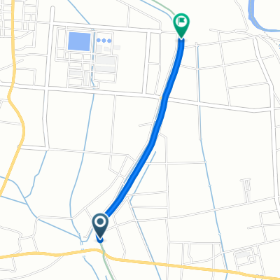
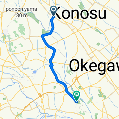
9 川幅日本一体感ルート
A cycling route starting in Kōnosu, Saitama, Japan.
Overview
About this route
- -:--
- Duration
- 14.4 km
- Distance
- 64 m
- Ascent
- 64 m
- Descent
- ---
- Avg. speed
- ---
- Max. altitude

Route quality
Waytypes & surfaces along the route
Waytypes
Track
2.7 km
(19 %)
Access road
2.6 km
(18 %)
Surfaces
Paved
1.4 km
(10 %)
Paved (undefined)
0.7 km
(5 %)
Asphalt
0.7 km
(5 %)
Undefined
13 km
(90 %)
Continue with Bikemap
Use, edit, or download this cycling route
You would like to ride 9 川幅日本一体感ルート or customize it for your own trip? Here is what you can do with this Bikemap route:
Free features
- Save this route as favorite or in collections
- Copy & plan your own version of this route
- Sync your route with Garmin or Wahoo
Premium features
Free trial for 3 days, or one-time payment. More about Bikemap Premium.
- Navigate this route on iOS & Android
- Export a GPX / KML file of this route
- Create your custom printout (try it for free)
- Download this route for offline navigation
Discover more Premium features.
Get Bikemap PremiumFrom our community
Other popular routes starting in Kōnosu
 9 川幅日本一体感ルート
- Distance
- 14.4 km
- Ascent
- 64 m
- Descent
- 64 m
- Location
- Kōnosu, Saitama, Japan
 Imaizumi, Yoshimi, Hiki-Gun to Kawataya, Okegawa
- Distance
- 11.5 km
- Ascent
- 94 m
- Descent
- 75 m
- Location
- Kōnosu, Saitama, Japan
 1124−1, 鴻巣市 to 鴻巣市
- Distance
- 32.3 km
- Ascent
- 122 m
- Descent
- 124 m
- Location
- Kōnosu, Saitama, Japan
 Recovered Route
- Distance
- 1.5 km
- Ascent
- 0 m
- Descent
- 3 m
- Location
- Kōnosu, Saitama, Japan
 Kōnosu - Okegawa
- Distance
- 14.8 km
- Ascent
- 13 m
- Descent
- 19 m
- Location
- Kōnosu, Saitama, Japan
 1124−4, 鴻巣市 to 1124−1, 鴻巣市
- Distance
- 30.5 km
- Ascent
- 134 m
- Descent
- 142 m
- Location
- Kōnosu, Saitama, Japan
 Arai, Kitamoto to Nishiasuma, Nishi, Saitama
- Distance
- 16.5 km
- Ascent
- 158 m
- Descent
- 163 m
- Location
- Kōnosu, Saitama, Japan
 4 農業用水路を走るルート
- Distance
- 55.8 km
- Ascent
- 143 m
- Descent
- 143 m
- Location
- Kōnosu, Saitama, Japan
Open it in the app