

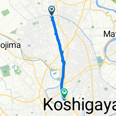
10 見沼の自然と埼スタぐるっとルート
A cycling route starting in Koshigaya, Saitama, Japan.
Overview
About this route
- -:--
- Duration
- 8 km
- Distance
- 30 m
- Ascent
- 28 m
- Descent
- ---
- Avg. speed
- ---
- Max. altitude

Route quality
Waytypes & surfaces along the route
Waytypes
Pedestrian area
2 km
(25 %)
Cycleway
1.8 km
(22 %)
Surfaces
Paved
2.2 km
(27 %)
Asphalt
1.5 km
(19 %)
Paved (undefined)
0.6 km
(8 %)
Undefined
5.8 km
(73 %)
Continue with Bikemap
Use, edit, or download this cycling route
You would like to ride 10 見沼の自然と埼スタぐるっとルート or customize it for your own trip? Here is what you can do with this Bikemap route:
Free features
- Save this route as favorite or in collections
- Copy & plan your own version of this route
- Sync your route with Garmin or Wahoo
Premium features
Free trial for 3 days, or one-time payment. More about Bikemap Premium.
- Navigate this route on iOS & Android
- Export a GPX / KML file of this route
- Create your custom printout (try it for free)
- Download this route for offline navigation
Discover more Premium features.
Get Bikemap PremiumFrom our community
Other popular routes starting in Koshigaya
 690, Ofusa, Koshigaya to Matsue, Soka
- Distance
- 8.2 km
- Ascent
- 6 m
- Descent
- 14 m
- Location
- Koshigaya, Saitama, Japan
 2丁目 6, 川口市 まで4丁目 3, 戸田市
- Distance
- 15.2 km
- Ascent
- 31 m
- Descent
- 35 m
- Location
- Koshigaya, Saitama, Japan
 2丁目 6, 川口市 まで1645番地の1, 川口市
- Distance
- 6.3 km
- Ascent
- 30 m
- Descent
- 30 m
- Location
- Koshigaya, Saitama, Japan
 Lake Town 9-Chōme, Koshigaya to 400-4, Oeda, Kasukabe
- Distance
- 11.6 km
- Ascent
- 0 m
- Descent
- 6 m
- Location
- Koshigaya, Saitama, Japan
 千間台西1丁目, 越谷市へ大沢2丁目, 越谷市
- Distance
- 4.8 km
- Ascent
- 6 m
- Descent
- 6 m
- Location
- Koshigaya, Saitama, Japan
 2丁目 6, 川口市 まで2丁目 6, 川口市
- Distance
- 29.1 km
- Ascent
- 160 m
- Descent
- 201 m
- Location
- Koshigaya, Saitama, Japan
 1853, Fukuroyama, Koshigaya to 439-2, Ushijima, Kasukabe
- Distance
- 8.4 km
- Ascent
- 39 m
- Descent
- 29 m
- Location
- Koshigaya, Saitama, Japan
 2丁目 6, 川口市 まで4丁目 1, 戸田市
- Distance
- 24.5 km
- Ascent
- 57 m
- Descent
- 92 m
- Location
- Koshigaya, Saitama, Japan
Open it in the app