

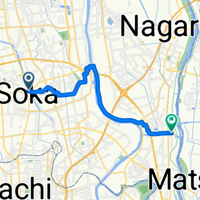
22 草加せんべい松並木のルート
A cycling route starting in Sōka, Saitama, Japan.
Overview
About this route
- -:--
- Duration
- 4.8 km
- Distance
- 25 m
- Ascent
- 33 m
- Descent
- ---
- Avg. speed
- ---
- Max. altitude

Continue with Bikemap
Use, edit, or download this cycling route
You would like to ride 22 草加せんべい松並木のルート or customize it for your own trip? Here is what you can do with this Bikemap route:
Free features
- Save this route as favorite or in collections
- Copy & plan your own version of this route
- Sync your route with Garmin or Wahoo
Premium features
Free trial for 3 days, or one-time payment. More about Bikemap Premium.
- Navigate this route on iOS & Android
- Export a GPX / KML file of this route
- Create your custom printout (try it for free)
- Download this route for offline navigation
Discover more Premium features.
Get Bikemap PremiumFrom our community
Other popular routes starting in Sōka
 396, Angyokichizo, Kawaguchi-Shi to Nikko-kaido Avenue, Koshigaya-Shi
- Distance
- 4.5 km
- Ascent
- 10 m
- Descent
- 8 m
- Location
- Sōka, Saitama, Japan
 県道34号, Kawaguchi to 319, Ushijima, Kasukabe
- Distance
- 18.8 km
- Ascent
- 31 m
- Descent
- 29 m
- Location
- Sōka, Saitama, Japan
 7-12, Ihara 2-Chōme, Koshigaya to 61, Tomuro, Kazo
- Distance
- 84.8 km
- Ascent
- 38 m
- Descent
- 40 m
- Location
- Sōka, Saitama, Japan
 16-1, Iko 4-Chōme, Adachi to 19-7, Hachimangi 2-Chōme, Kawaguchi
- Distance
- 4.5 km
- Ascent
- 3 m
- Descent
- 3 m
- Location
- Sōka, Saitama, Japan
 Omiya
Omiya- Distance
- 20.1 km
- Ascent
- 75 m
- Descent
- 55 m
- Location
- Sōka, Saitama, Japan
 Sakaecho 1-Chōme, Soka to Shinwa 2-Chōme, Misato
- Distance
- 11.8 km
- Ascent
- 51 m
- Descent
- 53 m
- Location
- Sōka, Saitama, Japan
 22 草加せんべい松並木のルート
- Distance
- 4.8 km
- Ascent
- 25 m
- Descent
- 33 m
- Location
- Sōka, Saitama, Japan
 1st Day - Nikko
- Distance
- 135.4 km
- Ascent
- 464 m
- Descent
- 97 m
- Location
- Sōka, Saitama, Japan
Open it in the app