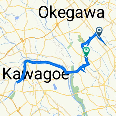
29 都市と自然の回遊軸ルート
A cycling route starting in Okegawa, Saitama, Japan.
Overview
About this route
- -:--
- Duration
- 10.5 km
- Distance
- 38 m
- Ascent
- 42 m
- Descent
- ---
- Avg. speed
- ---
- Avg. speed
Route quality
Waytypes & surfaces along the route
Waytypes
Quiet road
4.4 km
(42 %)
Road
3.1 km
(29 %)
Surfaces
Paved
1.6 km
(16 %)
Paved (undefined)
1.6 km
(16 %)
Undefined
8.9 km
(84 %)
Continue with Bikemap
Use, edit, or download this cycling route
You would like to ride 29 都市と自然の回遊軸ルート or customize it for your own trip? Here is what you can do with this Bikemap route:
Free features
- Save this route as favorite or in collections
- Copy & plan your own version of this route
- Sync your route with Garmin or Wahoo
Premium features
Free trial for 3 days, or one-time payment. More about Bikemap Premium.
- Navigate this route on iOS & Android
- Export a GPX / KML file of this route
- Create your custom printout (try it for free)
- Download this route for offline navigation
Discover more Premium features.
Get Bikemap PremiumFrom our community
Other popular routes starting in Okegawa
- 25-5, Idogi 3-Chōme, Ageo to 13-7, Idogi 3-Chōme, Ageo
- Distance
- 22.5 km
- Ascent
- 49 m
- Descent
- 48 m
- Location
- Okegawa, Saitama, Japan
- Demarushimogo, Kawajima, Hiki-Gun to Demarushimogo, Kawajima, Hiki-Gun
- Distance
- 28 km
- Ascent
- 185 m
- Descent
- 210 m
- Location
- Okegawa, Saitama, Japan
- 2丁目 9, 上尾市 まで4丁目, さいたま市
- Distance
- 12.5 km
- Ascent
- 7 m
- Descent
- 50 m
- Location
- Okegawa, Saitama, Japan
- 31 桶川・田園と川のルート
- Distance
- 21.8 km
- Ascent
- 49 m
- Descent
- 52 m
- Location
- Okegawa, Saitama, Japan
- 県道33号, Kitamoto to Zaike, Sakura, Saitama
- Distance
- 21.7 km
- Ascent
- 302 m
- Descent
- 330 m
- Location
- Okegawa, Saitama, Japan
- 2丁目 9, 上尾市 まで1丁目, 川越市
- Distance
- 24.2 km
- Ascent
- 71 m
- Descent
- 71 m
- Location
- Okegawa, Saitama, Japan
- Arakawa Exploring from Maruyama Park
- Distance
- 35.7 km
- Ascent
- 56 m
- Descent
- 56 m
- Location
- Okegawa, Saitama, Japan
- 1丁目 3, 桶川市 まで2丁目 3, 桶川市
- Distance
- 21.2 km
- Ascent
- 106 m
- Descent
- 106 m
- Location
- Okegawa, Saitama, Japan
Open it in the app