

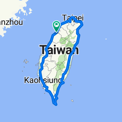
輕鬆的路線 東區
A cycling route starting in Hsinchu, Taiwan, Taiwan.
Overview
About this route
- 45 min
- Duration
- 13.2 km
- Distance
- 0 m
- Ascent
- 3 m
- Descent
- 17.5 km/h
- Avg. speed
- ---
- Max. altitude

Route quality
Waytypes & surfaces along the route
Waytypes
Road
5.1 km
(39 %)
Quiet road
2.2 km
(17 %)
Surfaces
Paved
4.3 km
(33 %)
Asphalt
4.3 km
(33 %)
Undefined
8.8 km
(67 %)
Continue with Bikemap
Use, edit, or download this cycling route
You would like to ride 輕鬆的路線 東區 or customize it for your own trip? Here is what you can do with this Bikemap route:
Free features
- Save this route as favorite or in collections
- Copy & plan your own version of this route
- Sync your route with Garmin or Wahoo
Premium features
Free trial for 3 days, or one-time payment. More about Bikemap Premium.
- Navigate this route on iOS & Android
- Export a GPX / KML file of this route
- Create your custom printout (try it for free)
- Download this route for offline navigation
Discover more Premium features.
Get Bikemap PremiumFrom our community
Other popular routes starting in Hsinchu
 20200822父子倆騎行17公里中段
- Distance
- 5.5 km
- Ascent
- 0 m
- Descent
- 3 m
- Location
- Hsinchu, Taiwan, Taiwan
 環島I
環島I- Distance
- 1,115.9 km
- Ascent
- 1,758 m
- Descent
- 1,758 m
- Location
- Hsinchu, Taiwan, Taiwan
 頭份~南庄~仙山~獅譚~錫溢隧道~苗栗~頭屋~頭份
- Distance
- 80.3 km
- Ascent
- 2,219 m
- Descent
- 2,148 m
- Location
- Hsinchu, Taiwan, Taiwan
 永和山水庫
永和山水庫- Distance
- 54.2 km
- Ascent
- 701 m
- Descent
- 754 m
- Location
- Hsinchu, Taiwan, Taiwan
 園區練騎路線 (青草湖、古奇峰) 25K_324m
- Distance
- 15.7 km
- Ascent
- 272 m
- Descent
- 270 m
- Location
- Hsinchu, Taiwan, Taiwan
 Part1 Day2 (4/4)新竹市~台中市
- Distance
- 107.6 km
- Ascent
- 399 m
- Descent
- 335 m
- Location
- Hsinchu, Taiwan, Taiwan
 老爺酒店-青草湖-古奇峄-清大土地公-交大土地公之-老爺酒店
- Distance
- 23.6 km
- Ascent
- 314 m
- Descent
- 319 m
- Location
- Hsinchu, Taiwan, Taiwan
 Nanliao, North District to E-W Expressway Nanliao-Zhudong Line, North District
- Distance
- 6.4 km
- Ascent
- 40 m
- Descent
- 34 m
- Location
- Hsinchu, Taiwan, Taiwan
Open it in the app