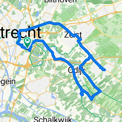
WAB - Bosbaan
A cycling route starting in Lunetten, Utrecht, The Netherlands.
Overview
About this route
- -:--
- Duration
- 158.6 km
- Distance
- 8 m
- Ascent
- 12 m
- Descent
- ---
- Avg. speed
- ---
- Max. altitude
Route quality
Waytypes & surfaces along the route
Waytypes
Road
55.5 km
(35 %)
Quiet road
52.3 km
(33 %)
Surfaces
Paved
99.9 km
(63 %)
Asphalt
99.9 km
(63 %)
Undefined
58.7 km
(37 %)
Continue with Bikemap
Use, edit, or download this cycling route
You would like to ride WAB - Bosbaan or customize it for your own trip? Here is what you can do with this Bikemap route:
Free features
- Save this route as favorite or in collections
- Copy & plan your own version of this route
- Split it into stages to create a multi-day tour
- Sync your route with Garmin or Wahoo
Premium features
Free trial for 3 days, or one-time payment. More about Bikemap Premium.
- Navigate this route on iOS & Android
- Export a GPX / KML file of this route
- Create your custom printout (try it for free)
- Download this route for offline navigation
Discover more Premium features.
Get Bikemap PremiumFrom our community
Other popular routes starting in Lunetten
- Tour du Bartimeus
- Distance
- 49.7 km
- Ascent
- 76 m
- Descent
- 78 m
- Location
- Lunetten, Utrecht, The Netherlands
- Lekdijk - Amerongen
- Distance
- 80.2 km
- Ascent
- 109 m
- Descent
- 108 m
- Location
- Lunetten, Utrecht, The Netherlands
- Rondje Leersum
- Distance
- 53.7 km
- Ascent
- 107 m
- Descent
- 103 m
- Location
- Lunetten, Utrecht, The Netherlands
- Langs de kust (Z-N)
- Distance
- 245.4 km
- Ascent
- 49 m
- Descent
- 51 m
- Location
- Lunetten, Utrecht, The Netherlands
- Slingeren om Houten heen
- Distance
- 29.7 km
- Ascent
- 12 m
- Descent
- 10 m
- Location
- Lunetten, Utrecht, The Netherlands
- Rondje Bussum
- Distance
- 85.7 km
- Ascent
- 66 m
- Descent
- 63 m
- Location
- Lunetten, Utrecht, The Netherlands
- Rondje Doorn-Amersfoort
- Distance
- 60.7 km
- Ascent
- 104 m
- Descent
- 104 m
- Location
- Lunetten, Utrecht, The Netherlands
- Rondje Utrecht
- Distance
- 22 km
- Ascent
- 12 m
- Descent
- 12 m
- Location
- Lunetten, Utrecht, The Netherlands
Open it in the app