

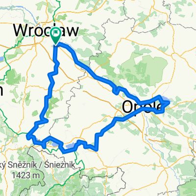
Wschodnia Obwodnica Wrocławia, Święta Katarzyna to Wietrzna 46a, Wrocław
A cycling route starting in Święta Katarzyna, Lower Silesian Voivodeship, Poland.
Overview
About this route
- 2 h 34 min
- Duration
- 27.1 km
- Distance
- 59 m
- Ascent
- 121 m
- Descent
- 10.6 km/h
- Avg. speed
- ---
- Avg. speed

Continue with Bikemap
Use, edit, or download this cycling route
You would like to ride Wschodnia Obwodnica Wrocławia, Święta Katarzyna to Wietrzna 46a, Wrocław or customize it for your own trip? Here is what you can do with this Bikemap route:
Free features
- Save this route as favorite or in collections
- Copy & plan your own version of this route
- Sync your route with Garmin or Wahoo
Premium features
Free trial for 3 days, or one-time payment. More about Bikemap Premium.
- Navigate this route on iOS & Android
- Export a GPX / KML file of this route
- Create your custom printout (try it for free)
- Download this route for offline navigation
Discover more Premium features.
Get Bikemap PremiumFrom our community
Other popular routes starting in Święta Katarzyna
 Jesienny wypad
- Distance
- 340.5 km
- Ascent
- 370 m
- Descent
- 369 m
- Location
- Święta Katarzyna, Lower Silesian Voivodeship, Poland
 Wschodnia Obwodnica Wrocławia, Święta Katarzyna to Wietrzna 46a, Wrocław
- Distance
- 27.1 km
- Ascent
- 59 m
- Descent
- 121 m
- Location
- Święta Katarzyna, Lower Silesian Voivodeship, Poland
 W koło Wrocławia
- Distance
- 83.4 km
- Ascent
- 56 m
- Descent
- 55 m
- Location
- Święta Katarzyna, Lower Silesian Voivodeship, Poland
 Józefa Bema 5, Święta Katarzyna to Spacerowa 102, Kotowice
- Distance
- 10.2 km
- Ascent
- 43 m
- Descent
- 46 m
- Location
- Święta Katarzyna, Lower Silesian Voivodeship, Poland
 Wrocław - Kraków - Szczucin
- Distance
- 427.6 km
- Ascent
- 278 m
- Descent
- 235 m
- Location
- Święta Katarzyna, Lower Silesian Voivodeship, Poland
 W koło Wrocławia
- Distance
- 55.9 km
- Ascent
- 60 m
- Descent
- 57 m
- Location
- Święta Katarzyna, Lower Silesian Voivodeship, Poland
 do Jaworzyna przez Wołowiec
- Distance
- 164.8 km
- Ascent
- 1,292 m
- Descent
- 1,188 m
- Location
- Święta Katarzyna, Lower Silesian Voivodeship, Poland
 Pabianice
- Distance
- 228 km
- Ascent
- 275 m
- Descent
- 207 m
- Location
- Święta Katarzyna, Lower Silesian Voivodeship, Poland
Open it in the app