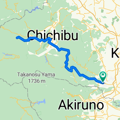
奥武蔵 峠めぐり
A cycling route starting in Hannō, Saitama, Japan.
Overview
About this route
- -:--
- Duration
- 57.7 km
- Distance
- 2,287 m
- Ascent
- 2,230 m
- Descent
- ---
- Avg. speed
- ---
- Avg. speed
Route quality
Waytypes & surfaces along the route
Waytypes
Quiet road
47.4 km
(82 %)
Busy road
5 km
(9 %)
Surfaces
Paved
30 km
(52 %)
Asphalt
28.6 km
(50 %)
Paved (undefined)
1.4 km
(2 %)
Undefined
27.7 km
(48 %)
Continue with Bikemap
Use, edit, or download this cycling route
You would like to ride 奥武蔵 峠めぐり or customize it for your own trip? Here is what you can do with this Bikemap route:
Free features
- Save this route as favorite or in collections
- Copy & plan your own version of this route
- Sync your route with Garmin or Wahoo
Premium features
Free trial for 3 days, or one-time payment. More about Bikemap Premium.
- Navigate this route on iOS & Android
- Export a GPX / KML file of this route
- Create your custom printout (try it for free)
- Download this route for offline navigation
Discover more Premium features.
Get Bikemap PremiumFrom our community
Other popular routes starting in Hannō
- 飯能ー奥武蔵グリーンラインー正丸-山伏-飯能
- Distance
- 74.9 km
- Ascent
- 1,197 m
- Descent
- 1,205 m
- Location
- Hannō, Saitama, Japan
- BRM707 PC0_PC1
- Distance
- 75.8 km
- Ascent
- 79 m
- Descent
- 143 m
- Location
- Hannō, Saitama, Japan
- 飯能駅~秩父駅ルート
- Distance
- 77.5 km
- Ascent
- 2,371 m
- Descent
- 2,373 m
- Location
- Hannō, Saitama, Japan
- 2013 飯能~名郷~秩父
- Distance
- 43.4 km
- Ascent
- 586 m
- Descent
- 459 m
- Location
- Hannō, Saitama, Japan
- 62 巾着田を発着点とした歴史と自然を感じるルート
- Distance
- 16.4 km
- Ascent
- 179 m
- Descent
- 177 m
- Location
- Hannō, Saitama, Japan
- 205−1, 日高市 まで日高市
- Distance
- 37.3 km
- Ascent
- 327 m
- Descent
- 365 m
- Location
- Hannō, Saitama, Japan
- Hanno to Nagatoro (return)
- Distance
- 124.3 km
- Ascent
- 1,615 m
- Descent
- 1,615 m
- Location
- Hannō, Saitama, Japan
- 飯能ー奥武蔵グリーンラインー秩父
- Distance
- 52.4 km
- Ascent
- 965 m
- Descent
- 837 m
- Location
- Hannō, Saitama, Japan
Open it in the app