

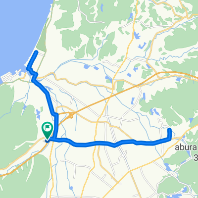
南あわじ市シティコース(中距離)
A cycling route starting in Fukura, Hyōgo, Japan.
Overview
About this route
- -:--
- Duration
- 39.7 km
- Distance
- 314 m
- Ascent
- 313 m
- Descent
- ---
- Avg. speed
- ---
- Max. altitude

Route quality
Waytypes & surfaces along the route
Waytypes
Quiet road
6 km
(15 %)
Road
2 km
(5 %)
Undefined
31.8 km
(80 %)
Continue with Bikemap
Use, edit, or download this cycling route
You would like to ride 南あわじ市シティコース(中距離) or customize it for your own trip? Here is what you can do with this Bikemap route:
Free features
- Save this route as favorite or in collections
- Copy & plan your own version of this route
- Sync your route with Garmin or Wahoo
Premium features
Free trial for 3 days, or one-time payment. More about Bikemap Premium.
- Navigate this route on iOS & Android
- Export a GPX / KML file of this route
- Create your custom printout (try it for free)
- Download this route for offline navigation
Discover more Premium features.
Get Bikemap PremiumFrom our community
Other popular routes starting in Fukura
 Minamiawaji Suisen Line, Minamiawaji to 925-22, Iwaya, Awaji
- Distance
- 87 km
- Ascent
- 9 m
- Descent
- 80 m
- Location
- Fukura, Hyōgo, Japan
 見どころバッチリ走破コース
- Distance
- 40.4 km
- Ascent
- 516 m
- Descent
- 514 m
- Location
- Fukura, Hyōgo, Japan
 南あわじ市シティコース(中距離)
- Distance
- 39.7 km
- Ascent
- 314 m
- Descent
- 313 m
- Location
- Fukura, Hyōgo, Japan
 南あわじ市シティコース(短距離)
- Distance
- 21.7 km
- Ascent
- 46 m
- Descent
- 47 m
- Location
- Fukura, Hyōgo, Japan
 Anaga, Minamiawaji to 1528-7, Fukura Ko, Minamiawaji
- Distance
- 6.2 km
- Ascent
- 136 m
- Descent
- 240 m
- Location
- Fukura, Hyōgo, Japan
 南あわじ市シティコース(長距離)
- Distance
- 60.1 km
- Ascent
- 894 m
- Descent
- 896 m
- Location
- Fukura, Hyōgo, Japan
 Uzushio Line, Minamiawaji to Uzushio Line, Minamiawaji
- Distance
- 1.8 km
- Ascent
- 97 m
- Descent
- 47 m
- Location
- Fukura, Hyōgo, Japan
 トライアングルコース(海)南あわじ市
- Distance
- 42 km
- Ascent
- 542 m
- Descent
- 543 m
- Location
- Fukura, Hyōgo, Japan
Open it in the app