

一般県道和田白浜館山自転車道線(太平洋岸自転車道)
A cycling route starting in Kamogawa, Chiba, Japan.
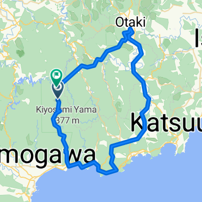
Overview
About this route
- -:--
- Duration
- 49.9 km
- Distance
- 239 m
- Ascent
- 242 m
- Descent
- ---
- Avg. speed
- ---
- Max. altitude

Continue with Bikemap
Use, edit, or download this cycling route
You would like to ride 一般県道和田白浜館山自転車道線(太平洋岸自転車道) or customize it for your own trip? Here is what you can do with this Bikemap route:
Free features
- Save this route as favorite or in collections
- Copy & plan your own version of this route
- Sync your route with Garmin or Wahoo
Premium features
Free trial for 3 days, or one-time payment. More about Bikemap Premium.
- Navigate this route on iOS & Android
- Export a GPX / KML file of this route
- Create your custom printout (try it for free)
- Download this route for offline navigation
Discover more Premium features.
Get Bikemap PremiumFrom our community
Other popular routes starting in Kamogawa
 Boso S3: Awa Kamogawa - Heguri - Hota
- Distance
- 61.4 km
- Ascent
- 371 m
- Descent
- 372 m
- Location
- Kamogawa, Chiba, Japan
 Boso S3: Awa Kamogawa - Tateyama
- Distance
- 66.9 km
- Ascent
- 165 m
- Descent
- 170 m
- Location
- Kamogawa, Chiba, Japan
 2011 清和の森サイクリング A60km
- Distance
- 58.9 km
- Ascent
- 1,444 m
- Descent
- 1,444 m
- Location
- Kamogawa, Chiba, Japan
 2011 清和の森サイクリング B110km
- Distance
- 104.5 km
- Ascent
- 3,346 m
- Descent
- 3,346 m
- Location
- Kamogawa, Chiba, Japan
 Boso S3: Awa Kamogawa - Kanaya
- Distance
- 92.7 km
- Ascent
- 218 m
- Descent
- 220 m
- Location
- Kamogawa, Chiba, Japan
 BAC-AwaKamogawa-BnH
- Distance
- 45.2 km
- Ascent
- 481 m
- Descent
- 481 m
- Location
- Kamogawa, Chiba, Japan
 Boso Risde Day 2 June '17
- Distance
- 81.9 km
- Ascent
- 1,078 m
- Descent
- 978 m
- Location
- Kamogawa, Chiba, Japan
 Awa-kominato
- Distance
- 63.5 km
- Ascent
- 762 m
- Descent
- 772 m
- Location
- Kamogawa, Chiba, Japan
Open it in the app