

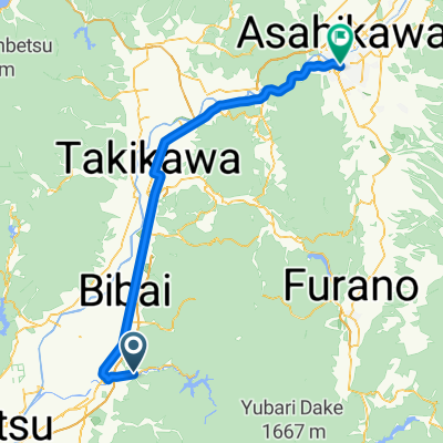
美唄観光フラットサイクリング15km
A cycling route starting in Bibai, Hokkaido, Japan.
Overview
About this route
- -:--
- Duration
- 15.4 km
- Distance
- 97 m
- Ascent
- 99 m
- Descent
- ---
- Avg. speed
- ---
- Max. altitude

Route quality
Waytypes & surfaces along the route
Waytypes
Road
9.2 km
(60 %)
Quiet road
4.6 km
(30 %)
Surfaces
Paved
1.2 km
(8 %)
Asphalt
1.2 km
(8 %)
Undefined
14.2 km
(92 %)
Continue with Bikemap
Use, edit, or download this cycling route
You would like to ride 美唄観光フラットサイクリング15km or customize it for your own trip? Here is what you can do with this Bikemap route:
Free features
- Save this route as favorite or in collections
- Copy & plan your own version of this route
- Sync your route with Garmin or Wahoo
Premium features
Free trial for 3 days, or one-time payment. More about Bikemap Premium.
- Navigate this route on iOS & Android
- Export a GPX / KML file of this route
- Create your custom printout (try it for free)
- Download this route for offline navigation
Discover more Premium features.
Get Bikemap PremiumFrom our community
Other popular routes starting in Bibai
 北海道單車 D3(opt.1) 美唄=>旭川 (~75.7k)
- Distance
- 75.7 km
- Ascent
- 326 m
- Descent
- 236 m
- Location
- Bibai, Hokkaido, Japan
 美唄ミドルライド35km
- Distance
- 32.7 km
- Ascent
- 80 m
- Descent
- 78 m
- Location
- Bibai, Hokkaido, Japan
 Furano
- Distance
- 49.4 km
- Ascent
- 791 m
- Descent
- 769 m
- Location
- Bibai, Hokkaido, Japan
 美唄観光フラットサイクリング15km
- Distance
- 15.4 km
- Ascent
- 97 m
- Descent
- 99 m
- Location
- Bibai, Hokkaido, Japan
 北海道自行車行D3
- Distance
- 93 km
- Ascent
- 326 m
- Descent
- 246 m
- Location
- Bibai, Hokkaido, Japan
 北海道單車 D3(opt.2) 美唄=>深川 (~52.3k)
- Distance
- 52.3 km
- Ascent
- 101 m
- Descent
- 72 m
- Location
- Bibai, Hokkaido, Japan
 北海道 Day03 美唄to富良野
- Distance
- 86.2 km
- Ascent
- 369 m
- Descent
- 227 m
- Location
- Bibai, Hokkaido, Japan
 Japan 2013, Day5, Lake Katsurazawa - Asahikawa
- Distance
- 122 km
- Ascent
- 840 m
- Descent
- 879 m
- Location
- Bibai, Hokkaido, Japan
Open it in the app