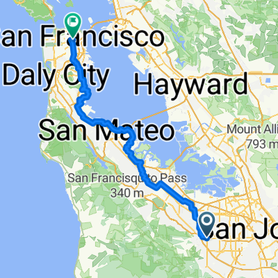
Prospect to Stanford
A cycling route starting in Cupertino, California, United States.
Overview
About this route
12 mile gentle ride
- -:--
- Duration
- 43.3 km
- Distance
- 203 m
- Ascent
- 193 m
- Descent
- ---
- Avg. speed
- ---
- Max. altitude
Route quality
Waytypes & surfaces along the route
Waytypes
Cycleway
12.7 km
(29 %)
Road
11 km
(25 %)
Surfaces
Paved
21.1 km
(49 %)
Asphalt
18.6 km
(43 %)
Paved (undefined)
2.4 km
(6 %)
Route highlights
Points of interest along the route
Point of interest after 1.8 km
Turn left
Point of interest after 2.4 km
Straight
Point of interest after 3.8 km
Carry on Mary
Point of interest after 4.9 km
Go up on the bridge
Point of interest after 5.6 km
Left turn
Point of interest after 7.4 km
Right turn onto foothill
Continue with Bikemap
Use, edit, or download this cycling route
You would like to ride Prospect to Stanford or customize it for your own trip? Here is what you can do with this Bikemap route:
Free features
- Save this route as favorite or in collections
- Copy & plan your own version of this route
- Sync your route with Garmin or Wahoo
Premium features
Free trial for 3 days, or one-time payment. More about Bikemap Premium.
- Navigate this route on iOS & Android
- Export a GPX / KML file of this route
- Create your custom printout (try it for free)
- Download this route for offline navigation
Discover more Premium features.
Get Bikemap PremiumFrom our community
Other popular routes starting in Cupertino
- Relaxed route in Cupertino
- Distance
- 5.4 km
- Ascent
- 74 m
- Descent
- 16 m
- Location
- Cupertino, California, United States
- Montebello Front & Back
- Distance
- 27.8 km
- Ascent
- 976 m
- Descent
- 944 m
- Location
- Cupertino, California, United States
- Stevens-Eden Mish Mash
- Distance
- 33.9 km
- Ascent
- 588 m
- Descent
- 591 m
- Location
- Cupertino, California, United States
- Cupertino Redwood Gulch
- Distance
- 31.7 km
- Ascent
- 634 m
- Descent
- 629 m
- Location
- Cupertino, California, United States
- home road loop
- Distance
- 30.4 km
- Ascent
- 304 m
- Descent
- 304 m
- Location
- Cupertino, California, United States
- Chuck's pretty ride.
- Distance
- 22.7 km
- Ascent
- 325 m
- Descent
- 326 m
- Location
- Cupertino, California, United States
- Stevens Creek - Redwood Gulch - Skyline - Page Mill Loop
- Distance
- 51 km
- Ascent
- 923 m
- Descent
- 923 m
- Location
- Cupertino, California, United States
- To the coast and back V3
- Distance
- 144.9 km
- Ascent
- 1,853 m
- Descent
- 1,853 m
- Location
- Cupertino, California, United States
Open it in the app