
Ukrajina 26.7.2010
A cycling route starting in Čierna nad Tisou, Košice Region, Slovakia.
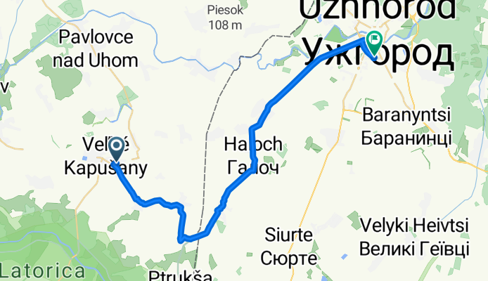
Overview
About this route
Previous day
Next day
- -:--
- Duration
- 28 km
- Distance
- 20 m
- Ascent
- 12 m
- Descent
- ---
- Avg. speed
- ---
- Max. altitude

Route quality
Waytypes & surfaces along the route
Waytypes
Road
20.4 km
(73 %)
Quiet road
3.6 km
(13 %)
Surfaces
Paved
7.6 km
(27 %)
Asphalt
7.6 km
(27 %)
Undefined
20.4 km
(73 %)
Route highlights
Points of interest along the route
Point of interest after 0.6 km
Snídaně a hurá do dalšího deštivého dne.
Drinking water after 8.8 km
Eurobar, občerstvení, opět prší.
Point of interest after 9.3 km
Přechod, už zase prší. Průchod trval 2 hodiny.
Point of interest after 26.5 km
Výměna peněz. Bez problémů... Už je veseleji, 2 hodiny nepršelo...
Point of interest after 28 km
Nádraží... Jízdenky na lepší vlaky se kupují v hlavmí budově. Na električky v budově v jižním směrem. Přijít na to trvalo 30minut. Pak následovala jízda ukrajinským panťákem s přestupem v Mukačevu.Úžasný zážitek.... Večeře v Mukačevu naproti nádraží.
Continue with Bikemap
Use, edit, or download this cycling route
You would like to ride Ukrajina 26.7.2010 or customize it for your own trip? Here is what you can do with this Bikemap route:
Free features
- Save this route as favorite or in collections
- Copy & plan your own version of this route
- Sync your route with Garmin or Wahoo
Premium features
Free trial for 3 days, or one-time payment. More about Bikemap Premium.
- Navigate this route on iOS & Android
- Export a GPX / KML file of this route
- Create your custom printout (try it for free)
- Download this route for offline navigation
Discover more Premium features.
Get Bikemap PremiumFrom our community
Other popular routes starting in Čierna nad Tisou
 Ukrajina 26.7.2010
- Distance
- 28 km
- Ascent
- 20 m
- Descent
- 12 m
- Location
- Čierna nad Tisou, Košice Region, Slovakia
 V. Kapušany – Košice
- Distance
- 83.5 km
- Ascent
- 438 m
- Descent
- 349 m
- Location
- Čierna nad Tisou, Košice Region, Slovakia
 Malé Trakany_Malá Tŕňa
- Distance
- 78 km
- Ascent
- 182 m
- Descent
- 124 m
- Location
- Čierna nad Tisou, Košice Region, Slovakia
 rychlovka cez Latoricu a visuty most
- Distance
- 28.5 km
- Ascent
- 35 m
- Descent
- 38 m
- Location
- Čierna nad Tisou, Košice Region, Slovakia
 Trakanská 5/17, Čierna nad Tisou až Trakanská 4/9, Čierna nad Tisou
- Distance
- 5 km
- Ascent
- 16 m
- Descent
- 16 m
- Location
- Čierna nad Tisou, Košice Region, Slovakia
 okruh Zakarpatská Rus
- Distance
- 295.8 km
- Ascent
- 1,397 m
- Descent
- 1,392 m
- Location
- Čierna nad Tisou, Košice Region, Slovakia
 Trakanská, Čierna nad Tisou až Jarná, Čierna nad Tisou
- Distance
- 18.9 km
- Ascent
- 9 m
- Descent
- 7 m
- Location
- Čierna nad Tisou, Košice Region, Slovakia
 Pribeník
- Distance
- 68.1 km
- Ascent
- 51 m
- Descent
- 55 m
- Location
- Čierna nad Tisou, Košice Region, Slovakia
Open it in the app