

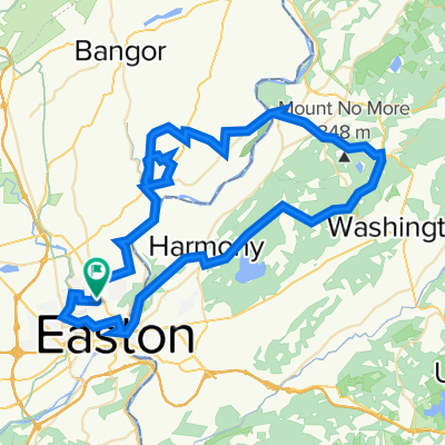
Up the river 40km. Bike map.net
A cycling route starting in Easton, Pennsylvania, United States of America.
Overview
About this route
- -:--
- Duration
- 45.4 km
- Distance
- 116 m
- Ascent
- 119 m
- Descent
- ---
- Avg. speed
- ---
- Max. altitude

Route quality
Waytypes & surfaces along the route
Waytypes
Path
28 km
(62 %)
Cycleway
14.3 km
(31 %)
Surfaces
Paved
16.8 km
(37 %)
Unpaved
27.8 km
(61 %)
Gravel
17.8 km
(39 %)
Asphalt
16.8 km
(37 %)
Continue with Bikemap
Use, edit, or download this cycling route
You would like to ride Up the river 40km. Bike map.net or customize it for your own trip? Here is what you can do with this Bikemap route:
Free features
- Save this route as favorite or in collections
- Copy & plan your own version of this route
- Sync your route with Garmin or Wahoo
Premium features
Free trial for 3 days, or one-time payment. More about Bikemap Premium.
- Navigate this route on iOS & Android
- Export a GPX / KML file of this route
- Create your custom printout (try it for free)
- Download this route for offline navigation
Discover more Premium features.
Get Bikemap PremiumFrom our community
Other popular routes starting in Easton
 Sophie
- Distance
- 9.6 km
- Ascent
- 98 m
- Descent
- 114 m
- Location
- Easton, Pennsylvania, United States of America
 1700 Sullivan Trail, Easton to 1800 Sullivan Trail, Easton
- Distance
- 58.8 km
- Ascent
- 547 m
- Descent
- 534 m
- Location
- Easton, Pennsylvania, United States of America
 700 Old Philadelphia Rd, Easton to 905 Line St, Easton
- Distance
- 1.6 km
- Ascent
- 22 m
- Descent
- 23 m
- Location
- Easton, Pennsylvania, United States of America
 Easton Journey! v2
- Distance
- 24.7 km
- Ascent
- 132 m
- Descent
- 149 m
- Location
- Easton, Pennsylvania, United States of America
 50km_Easton-Allentown-Easton
- Distance
- 50.1 km
- Ascent
- 92 m
- Descent
- 93 m
- Location
- Easton, Pennsylvania, United States of America
 Oxford Furnace - Oxford Furnace
- Distance
- 79.7 km
- Ascent
- 1,237 m
- Descent
- 1,235 m
- Location
- Easton, Pennsylvania, United States of America
 Up the river 40km. Bike map.net
- Distance
- 45.4 km
- Ascent
- 116 m
- Descent
- 119 m
- Location
- Easton, Pennsylvania, United States of America
 Karl Art
- Distance
- 3.4 km
- Ascent
- 17 m
- Descent
- 16 m
- Location
- Easton, Pennsylvania, United States of America
Open it in the app