

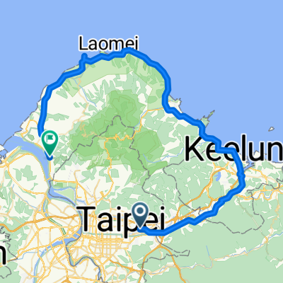
運動路線 淡水區
A cycling route starting in Taipei, Taipei, Taiwan.
Overview
About this route
- 1 h
- Duration
- 20.5 km
- Distance
- 0 m
- Ascent
- 9 m
- Descent
- 20.4 km/h
- Avg. speed
- ---
- Max. altitude

Continue with Bikemap
Use, edit, or download this cycling route
You would like to ride 運動路線 淡水區 or customize it for your own trip? Here is what you can do with this Bikemap route:
Free features
- Save this route as favorite or in collections
- Copy & plan your own version of this route
- Sync your route with Garmin or Wahoo
Premium features
Free trial for 3 days, or one-time payment. More about Bikemap Premium.
- Navigate this route on iOS & Android
- Export a GPX / KML file of this route
- Create your custom printout (try it for free)
- Download this route for offline navigation
Discover more Premium features.
Get Bikemap PremiumFrom our community
Other popular routes starting in Taipei
 永和-淡水來回
- Distance
- 71.1 km
- Ascent
- 90 m
- Descent
- 81 m
- Location
- Taipei, Taipei, Taiwan
 信義-崇德街-阿柔洋-碎心坡-草湳-貓空站-政大-萬芳社區-信義(O型)
- Distance
- 35.5 km
- Ascent
- 1,399 m
- Descent
- 1,376 m
- Location
- Taipei, Taipei, Taiwan
 2015 JAN 20-29 個人台灣環島
- Distance
- 1,029.1 km
- Ascent
- 1,680 m
- Descent
- 1,680 m
- Location
- Taipei, Taipei, Taiwan
 信義河濱-故宮-平等里-冷水坑-二子坪-八拉卡-紅樹林-河濱-公館(O型)
- Distance
- 84.1 km
- Ascent
- 1,319 m
- Descent
- 1,338 m
- Location
- Taipei, Taipei, Taiwan
 P字道
P字道- Distance
- 76.1 km
- Ascent
- 2,461 m
- Descent
- 2,021 m
- Location
- Taipei, Taipei, Taiwan
 20081011 北海岸1
- Distance
- 80.8 km
- Ascent
- 392 m
- Descent
- 383 m
- Location
- Taipei, Taipei, Taiwan
 Sep.14,10-環大台北練習
- Distance
- 168.3 km
- Ascent
- 703 m
- Descent
- 703 m
- Location
- Taipei, Taipei, Taiwan
 腳踏車環島 2011/01/20~2011/01/31
- Distance
- 1,239.7 km
- Ascent
- 1,590 m
- Descent
- 1,590 m
- Location
- Taipei, Taipei, Taiwan
Open it in the app