
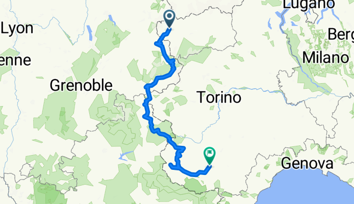
Aosta-Cuneo, zwischen Frankreich und Italien
A cycling route starting in Prè-Saint-Didier, Aosta Valley, Italy.
Overview
About this route
Sechs Tage Tour
Schlafen im Zelt und Unterkünften
Schotter nur auf der Piano de Gardetta. Ein lohnenswerter Abstecher auf einer alten Militärstrasse.
Bikemap rechnet 12'600 Höhenmeter vor, mein Höhenmasser kommt auf knapp 10'000.
Zwischen Modane und Bardonechia haben wir uns durch den Tunnel chauffieren lassen. Da muss man sich informieren, Mit dem Taxi war das recht teuer.
Oben durch sollte auch gehen. Es soll nur ein kleines Stück sein, welches man auf einem Wanderweg zurücklegen muss. Der Rest ist Asphalt oder Schotter.
- -:--
- Duration
- 427.4 km
- Distance
- 9,096 m
- Ascent
- 9,593 m
- Descent
- ---
- Avg. speed
- ---
- Max. altitude
Route highlights
Points of interest along the route
Point of interest after 262 km
Continue with Bikemap
Use, edit, or download this cycling route
You would like to ride Aosta-Cuneo, zwischen Frankreich und Italien or customize it for your own trip? Here is what you can do with this Bikemap route:
Free features
- Save this route as favorite or in collections
- Copy & plan your own version of this route
- Split it into stages to create a multi-day tour
- Sync your route with Garmin or Wahoo
Premium features
Free trial for 3 days, or one-time payment. More about Bikemap Premium.
- Navigate this route on iOS & Android
- Export a GPX / KML file of this route
- Create your custom printout (try it for free)
- Download this route for offline navigation
Discover more Premium features.
Get Bikemap PremiumFrom our community
Other popular routes starting in Prè-Saint-Didier
 Tour des Alpes occidentales 4. Etappe
- Distance
- 61.1 km
- Ascent
- 1,896 m
- Descent
- 1,090 m
- Location
- Prè-Saint-Didier, Aosta Valley, Italy
 5: PRÉ-SAINT-DIDIER / COLLE DEL GRAN SAN BERNARDO
- Distance
- 87.3 km
- Ascent
- 2,697 m
- Descent
- 1,273 m
- Location
- Prè-Saint-Didier, Aosta Valley, Italy
 Tag 4 Pre St Didier- Val Savarenche Hotel du Paradis 2.0
- Distance
- 46.5 km
- Ascent
- 1,549 m
- Descent
- 890 m
- Location
- Prè-Saint-Didier, Aosta Valley, Italy
 TMB Stage1
- Distance
- 142.2 km
- Ascent
- 3,020 m
- Descent
- 3,001 m
- Location
- Prè-Saint-Didier, Aosta Valley, Italy
 der kleine San Bernhardtpass
- Distance
- 23.9 km
- Ascent
- 1,238 m
- Descent
- 39 m
- Location
- Prè-Saint-Didier, Aosta Valley, Italy
 Courmayeur
- Distance
- 61.6 km
- Ascent
- 1,561 m
- Descent
- 1,572 m
- Location
- Prè-Saint-Didier, Aosta Valley, Italy
 2011 Bernard - 05 - Piccolo St. Bernard - 2188 m
- Distance
- 79.7 km
- Ascent
- 2,138 m
- Descent
- 1,427 m
- Location
- Prè-Saint-Didier, Aosta Valley, Italy
 AlpenTour2018_E5-8
- Distance
- 129.3 km
- Ascent
- 1,944 m
- Descent
- 2,526 m
- Location
- Prè-Saint-Didier, Aosta Valley, Italy
Open it in the app