

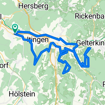
Rehag
A cycling route starting in Lausen, Basel-Landschaft, Switzerland.
Overview
About this route
- 4 h 38 min
- Duration
- 43.6 km
- Distance
- 1,561 m
- Ascent
- 1,558 m
- Descent
- 9.4 km/h
- Avg. speed
- ---
- Max. altitude

Route photos


Continue with Bikemap
Use, edit, or download this cycling route
You would like to ride Rehag or customize it for your own trip? Here is what you can do with this Bikemap route:
Free features
- Save this route as favorite or in collections
- Copy & plan your own version of this route
- Sync your route with Garmin or Wahoo
Premium features
Free trial for 3 days, or one-time payment. More about Bikemap Premium.
- Navigate this route on iOS & Android
- Export a GPX / KML file of this route
- Create your custom printout (try it for free)
- Download this route for offline navigation
Discover more Premium features.
Get Bikemap PremiumFrom our community
Other popular routes starting in Lausen
 Rehag
Rehag- Distance
- 43.6 km
- Ascent
- 1,561 m
- Descent
- 1,558 m
- Location
- Lausen, Basel-Landschaft, Switzerland
 Unterdorfstrasse 54, Lausen to Unterdorfstrasse 54, Lausen
- Distance
- 33.6 km
- Ascent
- 1,891 m
- Descent
- 1,890 m
- Location
- Lausen, Basel-Landschaft, Switzerland
 Herrenberg/Bürenflueh
- Distance
- 41.5 km
- Ascent
- 1,532 m
- Descent
- 1,532 m
- Location
- Lausen, Basel-Landschaft, Switzerland
 Lausen nach Lausen
- Distance
- 27.7 km
- Ascent
- 675 m
- Descent
- 675 m
- Location
- Lausen, Basel-Landschaft, Switzerland
 Route in Lausen
- Distance
- 26.4 km
- Ascent
- 582 m
- Descent
- 582 m
- Location
- Lausen, Basel-Landschaft, Switzerland
 Lausen - Efringen-Kirchen
- Distance
- 31.5 km
- Ascent
- 55 m
- Descent
- 142 m
- Location
- Lausen, Basel-Landschaft, Switzerland
 Lausen - Grenzach - Bad Bellingen
- Distance
- 43.3 km
- Ascent
- 131 m
- Descent
- 224 m
- Location
- Lausen, Basel-Landschaft, Switzerland
 Ruine Scheidegg
- Distance
- 32.6 km
- Ascent
- 951 m
- Descent
- 952 m
- Location
- Lausen, Basel-Landschaft, Switzerland
Open it in the app