

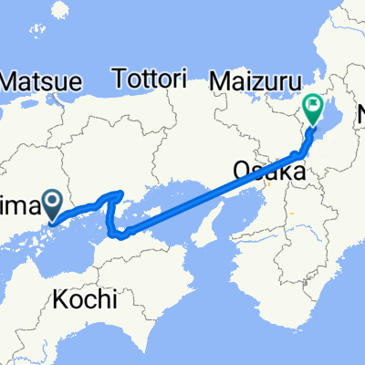
Innoshimaohimacho to Kashima Ferry
A cycling route starting in Onomichi, Hiroshima, Japan.
Overview
About this route
Daihamasaki Camping Ground to Kashima Camping Ground
- -:--
- Duration
- 88.5 km
- Distance
- 325 m
- Ascent
- 334 m
- Descent
- ---
- Avg. speed
- ---
- Max. altitude

Continue with Bikemap
Use, edit, or download this cycling route
You would like to ride Innoshimaohimacho to Kashima Ferry or customize it for your own trip? Here is what you can do with this Bikemap route:
Free features
- Save this route as favorite or in collections
- Copy & plan your own version of this route
- Split it into stages to create a multi-day tour
- Sync your route with Garmin or Wahoo
Premium features
Free trial for 3 days, or one-time payment. More about Bikemap Premium.
- Navigate this route on iOS & Android
- Export a GPX / KML file of this route
- Create your custom printout (try it for free)
- Download this route for offline navigation
Discover more Premium features.
Get Bikemap PremiumFrom our community
Other popular routes starting in Onomichi
 Route to Setodachokone, Onomichi
- Distance
- 35.2 km
- Ascent
- 753 m
- Descent
- 749 m
- Location
- Onomichi, Hiroshima, Japan
 Onomichi bike trip
- Distance
- 102.5 km
- Ascent
- 438 m
- Descent
- 436 m
- Location
- Onomichi, Hiroshima, Japan
 Innoshimaohimacho to Kashima Ferry
- Distance
- 88.5 km
- Ascent
- 325 m
- Descent
- 334 m
- Location
- Onomichi, Hiroshima, Japan
 Japon 2014 - Onomichi >> Hiroshima
- Distance
- 97.6 km
- Ascent
- 627 m
- Descent
- 631 m
- Location
- Onomichi, Hiroshima, Japan
 Route to 近江舞子
- Distance
- 395.7 km
- Ascent
- 2,745 m
- Descent
- 2,723 m
- Location
- Onomichi, Hiroshima, Japan
 Onomichi to Niihama
- Distance
- 101.4 km
- Ascent
- 1,918 m
- Descent
- 1,888 m
- Location
- Onomichi, Hiroshima, Japan
 OnomichitoTakamatsu
- Distance
- 218.9 km
- Ascent
- 339 m
- Descent
- 344 m
- Location
- Onomichi, Hiroshima, Japan
 Lengthy bike tour from 尾道市 to 今治市
- Distance
- 62 km
- Ascent
- 563 m
- Descent
- 501 m
- Location
- Onomichi, Hiroshima, Japan
Open it in the app