

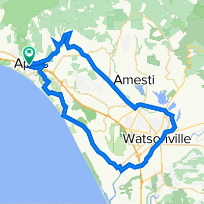
quarantine ride w/ dana
A cycling route starting in Aptos, California, United States.
Overview
About this route
- 1 h 3 min
- Duration
- 12.3 km
- Distance
- 136 m
- Ascent
- 135 m
- Descent
- 11.7 km/h
- Avg. speed
- ---
- Max. altitude

Route photos


Route quality
Waytypes & surfaces along the route
Waytypes
Track
8.2 km
(67 %)
Road
2.2 km
(18 %)
Surfaces
Paved
2.2 km
(18 %)
Unpaved
8.1 km
(66 %)
Unpaved (undefined)
8.1 km
(66 %)
Paved (undefined)
1.3 km
(11 %)
Continue with Bikemap
Use, edit, or download this cycling route
You would like to ride quarantine ride w/ dana or customize it for your own trip? Here is what you can do with this Bikemap route:
Free features
- Save this route as favorite or in collections
- Copy & plan your own version of this route
- Sync your route with Garmin or Wahoo
Premium features
Free trial for 3 days, or one-time payment. More about Bikemap Premium.
- Navigate this route on iOS & Android
- Export a GPX / KML file of this route
- Create your custom printout (try it for free)
- Download this route for offline navigation
Discover more Premium features.
Get Bikemap PremiumFrom our community
Other popular routes starting in Aptos
 Watsonville Loop v2
- Distance
- 49.3 km
- Ascent
- 307 m
- Descent
- 307 m
- Location
- Aptos, California, United States
 Forest of Nisene Marks
- Distance
- 16.4 km
- Ascent
- 503 m
- Descent
- 503 m
- Location
- Aptos, California, United States
 Nisene Marks fire road
- Distance
- 16.8 km
- Ascent
- 935 m
- Descent
- 215 m
- Location
- Aptos, California, United States
 US: Aptos 002
- Distance
- 119.6 km
- Ascent
- 1,361 m
- Descent
- 1,361 m
- Location
- Aptos, California, United States
 Aptos Long Loop
- Distance
- 101.1 km
- Ascent
- 962 m
- Descent
- 964 m
- Location
- Aptos, California, United States
 Aptos-Corralitos-Watsonville
- Distance
- 60.5 km
- Ascent
- 511 m
- Descent
- 513 m
- Location
- Aptos, California, United States
 Corralitos Loop
- Distance
- 32.2 km
- Ascent
- 328 m
- Descent
- 305 m
- Location
- Aptos, California, United States
 quarantine ride w/ dana
- Distance
- 12.3 km
- Ascent
- 136 m
- Descent
- 135 m
- Location
- Aptos, California, United States
Open it in the app