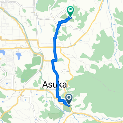
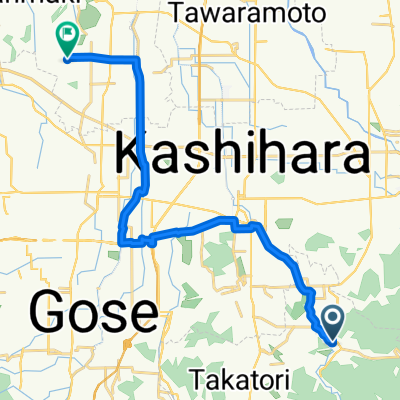
【奈良県】おすすめ桜(お花見)サイクリングコース~大和高田-藤原宮跡-明日香+談山神社編~_石舞台古墳~談山神社
A cycling route starting in Sakurai, Nara, Japan.
Overview
About this route
- -:--
- Duration
- 10.2 km
- Distance
- 447 m
- Ascent
- 442 m
- Descent
- ---
- Avg. speed
- ---
- Max. altitude
Route quality
Waytypes & surfaces along the route
Waytypes
Quiet road
0.6 km
(6 %)
Undefined
9.6 km
(94 %)
Surfaces
Paved
9.3 km
(91 %)
Paved (undefined)
9.3 km
(91 %)
Undefined
0.9 km
(9 %)
Continue with Bikemap
Use, edit, or download this cycling route
You would like to ride 【奈良県】おすすめ桜(お花見)サイクリングコース~大和高田-藤原宮跡-明日香+談山神社編~_石舞台古墳~談山神社 or customize it for your own trip? Here is what you can do with this Bikemap route:
Free features
- Save this route as favorite or in collections
- Copy & plan your own version of this route
- Sync your route with Garmin or Wahoo
Premium features
Free trial for 3 days, or one-time payment. More about Bikemap Premium.
- Navigate this route on iOS & Android
- Export a GPX / KML file of this route
- Create your custom printout (try it for free)
- Download this route for offline navigation
Discover more Premium features.
Get Bikemap PremiumFrom our community
Other popular routes starting in Sakurai
明日香村 to 1214−1, 奈良市- Distance
- 30.7 km
- Ascent
- 26 m
- Descent
- 6 m
- Location
- Sakurai, Nara, Japan
51−1, 明日香村 to 1丁目 3, 奈良市- Distance
- 33.3 km
- Ascent
- 215 m
- Descent
- 281 m
- Location
- Sakurai, Nara, Japan
明日香村 to 明日香村- Distance
- 5.5 km
- Ascent
- 33 m
- Descent
- 34 m
- Location
- Sakurai, Nara, Japan
Easy ride in Asuka-Mura, Takaichi-Gun- Distance
- 19.6 km
- Ascent
- 207 m
- Descent
- 278 m
- Location
- Sakurai, Nara, Japan
ETAPA 13. Asuka - Kyoto- Distance
- 70.8 km
- Ascent
- 100 m
- Descent
- 194 m
- Location
- Sakurai, Nara, Japan
一般県道明日香大和郡山自転車道線(飛鳥葛城自転車道)- Distance
- 28.3 km
- Ascent
- 105 m
- Descent
- 183 m
- Location
- Sakurai, Nara, Japan
179-1, Shimasho, Asuka-Mura, Takaichi-Gun to Minamiyamacho, Kashihara-Shi- Distance
- 3.7 km
- Ascent
- 22 m
- Descent
- 56 m
- Location
- Sakurai, Nara, Japan
いにしえのみやこをめぐる自転車の旅- Distance
- 88 km
- Ascent
- 434 m
- Descent
- 539 m
- Location
- Sakurai, Nara, Japan
Open it in the app


