

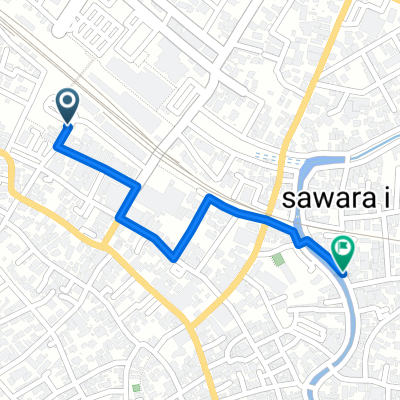
【徹底解剖その3】B.B.BASEのモデルコースをご紹介します!_佐原コース(ショートコース)
A cycling route starting in Katori-shi, Chiba, Japan.
Overview
About this route
- -:--
- Duration
- 11.9 km
- Distance
- 57 m
- Ascent
- 56 m
- Descent
- ---
- Avg. speed
- ---
- Max. altitude

Continue with Bikemap
Use, edit, or download this cycling route
You would like to ride 【徹底解剖その3】B.B.BASEのモデルコースをご紹介します!_佐原コース(ショートコース) or customize it for your own trip? Here is what you can do with this Bikemap route:
Free features
- Save this route as favorite or in collections
- Copy & plan your own version of this route
- Sync your route with Garmin or Wahoo
Premium features
Free trial for 3 days, or one-time payment. More about Bikemap Premium.
- Navigate this route on iOS & Android
- Export a GPX / KML file of this route
- Create your custom printout (try it for free)
- Download this route for offline navigation
Discover more Premium features.
Get Bikemap PremiumFrom our community
Other popular routes starting in Katori-shi
 Ryokan Ichiranso
- Distance
- 0.8 km
- Ascent
- 0 m
- Descent
- 0 m
- Location
- Katori-shi, Chiba, Japan
 名所めぐり中央コース
- Distance
- 84.9 km
- Ascent
- 222 m
- Descent
- 194 m
- Location
- Katori-shi, Chiba, Japan
 LOB: Sawara - Narita A.P. (via Horse Farms)
- Distance
- 27.9 km
- Ascent
- 148 m
- Descent
- 119 m
- Location
- Katori-shi, Chiba, Japan
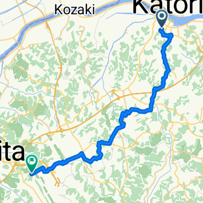
 Kozaki-Sawara
- Distance
- 13.5 km
- Ascent
- 37 m
- Descent
- 37 m
- Location
- Katori-shi, Chiba, Japan
 BR-CCT-Sawara-Choshi
- Distance
- 98.9 km
- Ascent
- 119 m
- Descent
- 119 m
- Location
- Katori-shi, Chiba, Japan
 佐原コース(ロングコース)
- Distance
- 65.2 km
- Ascent
- 460 m
- Descent
- 459 m
- Location
- Katori-shi, Chiba, Japan
 Boso S1: Sawara - Chiba
- Distance
- 77.3 km
- Ascent
- 206 m
- Descent
- 203 m
- Location
- Katori-shi, Chiba, Japan
 Sawara-CapeNojima: Toke-Kururi
- Distance
- 213.1 km
- Ascent
- 1,008 m
- Descent
- 1,009 m
- Location
- Katori-shi, Chiba, Japan
Open it in the app