

【秋田県】なまはげの聖地!男鹿をレンタサイクルでサイクリング!_JR男鹿駅周辺サイクリング
A cycling route starting in Tennō, Akita, Japan.
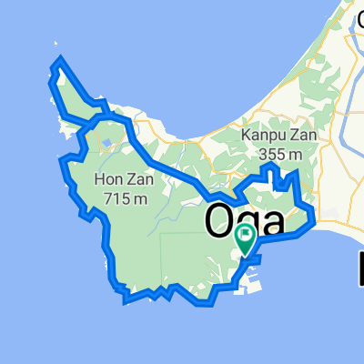
Overview
About this route
- -:--
- Duration
- 9.8 km
- Distance
- 10 m
- Ascent
- 12 m
- Descent
- ---
- Avg. speed
- ---
- Max. altitude

Route quality
Waytypes & surfaces along the route
Waytypes
Road
5.6 km
(57 %)
Quiet road
1.6 km
(16 %)
Continue with Bikemap
Use, edit, or download this cycling route
You would like to ride 【秋田県】なまはげの聖地!男鹿をレンタサイクルでサイクリング!_JR男鹿駅周辺サイクリング or customize it for your own trip? Here is what you can do with this Bikemap route:
Free features
- Save this route as favorite or in collections
- Copy & plan your own version of this route
- Sync your route with Garmin or Wahoo
Premium features
Free trial for 3 days, or one-time payment. More about Bikemap Premium.
- Navigate this route on iOS & Android
- Export a GPX / KML file of this route
- Create your custom printout (try it for free)
- Download this route for offline navigation
Discover more Premium features.
Get Bikemap PremiumFrom our community
Other popular routes starting in Tennō
 1, Funagawaminatofunagawa Shinhamacho, Oga to 1, Funagawaminatofunagawa Shinhamacho, Oga
- Distance
- 60.2 km
- Ascent
- 1,259 m
- Descent
- 1,259 m
- Location
- Tennō, Akita, Japan
 天王上江川47-412, 潟上市 to 国道101号, 秋田市
- Distance
- 7.9 km
- Ascent
- 23 m
- Descent
- 32 m
- Location
- Tennō, Akita, Japan
 新浜町 まで外ケ沢
- Distance
- 81.5 km
- Ascent
- 1,181 m
- Descent
- 1,219 m
- Location
- Tennō, Akita, Japan
 24-3, Funagawaminatofunagawa Sakaecho, Oga to 県道59号, Oga
- Distance
- 7.6 km
- Ascent
- 0 m
- Descent
- 7 m
- Location
- Tennō, Akita, Japan
 ghk
ghk- Distance
- 14.7 km
- Ascent
- 5 m
- Descent
- 4 m
- Location
- Tennō, Akita, Japan
 男鹿半島一周
- Distance
- 80.6 km
- Ascent
- 1,728 m
- Descent
- 1,729 m
- Location
- Tennō, Akita, Japan
 Shinzeki, Ikawa to 7-chōme 2, Akita
- Distance
- 18.7 km
- Ascent
- 101 m
- Descent
- 57 m
- Location
- Tennō, Akita, Japan
 12-3, Funagawaminatofunagawa Kaigandori1Go, Oga to Kitauranyudozaki Kombura, Oga
- Distance
- 33.8 km
- Ascent
- 0 m
- Descent
- 4 m
- Location
- Tennō, Akita, Japan
Open it in the app