

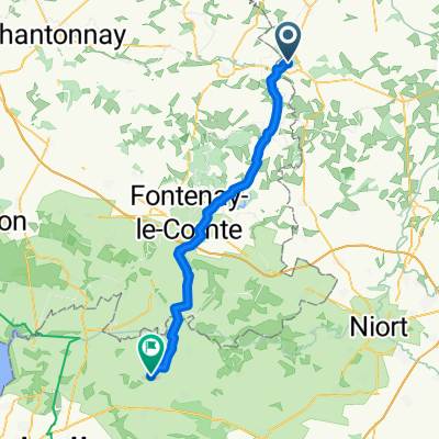
La Moncelière, Saint-Pierre-du-Chemin to La Moncelière, Saint-Pierre-du-Chemin
A cycling route starting in Saint-Pierre-du-Chemin, Pays de la Loire Region, France.
Overview
About this route
- 37 min
- Duration
- 10.5 km
- Distance
- 128 m
- Ascent
- 126 m
- Descent
- 17.2 km/h
- Avg. speed
- ---
- Max. altitude

Route quality
Waytypes & surfaces along the route
Waytypes
Quiet road
6.4 km
(61 %)
Road
2.5 km
(24 %)
Continue with Bikemap
Use, edit, or download this cycling route
You would like to ride La Moncelière, Saint-Pierre-du-Chemin to La Moncelière, Saint-Pierre-du-Chemin or customize it for your own trip? Here is what you can do with this Bikemap route:
Free features
- Save this route as favorite or in collections
- Copy & plan your own version of this route
- Sync your route with Garmin or Wahoo
Premium features
Free trial for 3 days, or one-time payment. More about Bikemap Premium.
- Navigate this route on iOS & Android
- Export a GPX / KML file of this route
- Create your custom printout (try it for free)
- Download this route for offline navigation
Discover more Premium features.
Get Bikemap PremiumFrom our community
Other popular routes starting in Saint-Pierre-du-Chemin
 La Communauté, Saint-Paul-en-Gâtine to Rue Saint-Jean, Saint-Jean-de-Liversay
- Distance
- 58.4 km
- Ascent
- 322 m
- Descent
- 522 m
- Location
- Saint-Pierre-du-Chemin, Pays de la Loire Region, France
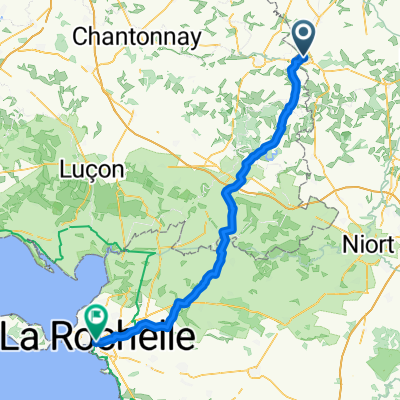 New Day 5 - La Rochelle
- Distance
- 87.1 km
- Ascent
- 350 m
- Descent
- 550 m
- Location
- Saint-Pierre-du-Chemin, Pays de la Loire Region, France
 mardi 24 mars
- Distance
- 10.5 km
- Ascent
- 128 m
- Descent
- 126 m
- Location
- Saint-Pierre-du-Chemin, Pays de la Loire Region, France
 De La Brionnière 2, Saint-Pierre-du-Chemin à Rue du Château Neuf 37, Vouvant
- Distance
- 20.3 km
- Ascent
- 183 m
- Descent
- 306 m
- Location
- Saint-Pierre-du-Chemin, Pays de la Loire Region, France
 Summer 10 85k France
- Distance
- 84.2 km
- Ascent
- 231 m
- Descent
- 397 m
- Location
- Saint-Pierre-du-Chemin, Pays de la Loire Region, France
 Day 5 - Saint-Paul-en-Gâtine - La Rochelle
- Distance
- 91.9 km
- Ascent
- 473 m
- Descent
- 677 m
- Location
- Saint-Pierre-du-Chemin, Pays de la Loire Region, France
 dimanche 22 mars
- Distance
- 10.6 km
- Ascent
- 118 m
- Descent
- 165 m
- Location
- Saint-Pierre-du-Chemin, Pays de la Loire Region, France
 Aug 2010 60k circuit
- Distance
- 61.1 km
- Ascent
- 458 m
- Descent
- 459 m
- Location
- Saint-Pierre-du-Chemin, Pays de la Loire Region, France
Open it in the app